Latitude: 51.0567 / 51°3'24"N
Longitude: -2.4103 / 2°24'37"W
OS Eastings: 371339
OS Northings: 128673
OS Grid: ST713286
Mapcode National: GBR MZ.FP55
Mapcode Global: FRA 56VB.6TL
Plus Code: 9C3V3H4Q+MV
Entry Name: 7, High Street
Listing Date: 24 March 1961
Grade: II
Source: Historic England
Source ID: 1238558
English Heritage Legacy ID: 416101
ID on this website: 101238558
Location: Wincanton, Somerset, BA9
County: Somerset
District: South Somerset
Civil Parish: Wincanton
Built-Up Area: Wincanton
Traditional County: Somerset
Lieutenancy Area (Ceremonial County): Somerset
Tagged with: Building
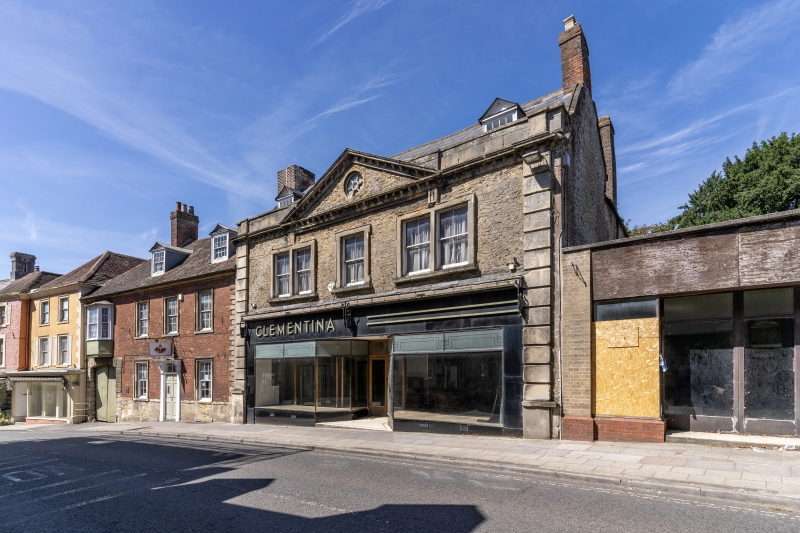
ST7128 WINCANTON CP HIGH STREET (North side)
8/139 No 7
24.3.61
GV II
Shop with house. C17 and C18, modified. Local stone rubble with ashlar dressing; Welsh slate roof between coped gables
behind parapet to front; brick end chimney stacks. 2 storeys with attic, South elevation 3 bays plinth, rusticated
pilasters, bracketed cornice with central pediment in otherwise plain parapet; 1930's black glass and bronze frame
shopfront with central recessed glazed doors; above 4-pane sash windows in heeled and shouldered architraves, the outer
bays doubled; circular window in pediment, and pitched roof dormer windows behind parapet; this facade could be by
Nathaniel Ireson. To right a C20 shop extension not included in the listing. rear has double glazed elevation, with a
curved central projection with flat roof for the staircase: C19 ground floor window and first floor bay 3, to first
floor bay 1 a sash window in architrave with triple keystone, and to attic gables 2-light ovolo-mould mullioned windows
under labels; part glazed door in panelled recess to stairwall, with early C19 style flat roofed porch; above
semi-circular headed window with rusticated architrave; coping moulded, with bust set in centre. Interior not seen -
most of ground floor much altered. The 1929 O.S map calls this the Rectory; the forbear of the shop owners, in business
for many years, was a founder for the local Roman Catholic community.
Listing NGR: ST7133928673
External links are from the relevant listing authority and, where applicable, Wikidata. Wikidata IDs may be related buildings as well as this specific building. If you want to add or update a link, you will need to do so by editing the Wikidata entry.


Other nearby listed buildings