Approximate Location Map
Large Map »
Latitude: 51.3171 / 51°19'1"N
Longitude: 0.8844 / 0°53'3"E
OS Eastings: 601098
OS Northings: 161506
OS Grid: TR010615
Mapcode National: GBR SW3.8G3
Mapcode Global: VHKJW.85X4
Plus Code: 9F328V8M+RQ
Entry Name: Faversham Stonebridge Lodge
Listing Date: 14 April 1980
Grade: II
Source: Historic England
Source ID: 1240312
English Heritage Legacy ID: 438694
ID on this website: 101240312
Location: Davington, Swale, Kent, ME13
County: Kent
District: Swale
Civil Parish: Faversham
Built-Up Area: Faversham
Traditional County: Kent
Lieutenancy Area (Ceremonial County): Kent
Tagged with: Gatehouse
FAVERSHAM
659/2/309 WEST STREET
14-APR-80 FAVERSHAM
STONEBRIDGE LODGE
II
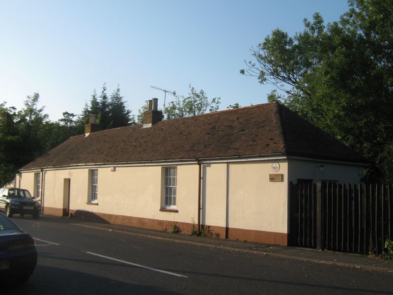
Watch house at gunpowder works; armoury during Napoleonic War; school 1848-61; now house. Late C18, altered C19 and late C20. Rendered brick with two short brick ridge stacks to left end and tiled hipped roof.
PLAN: Single-depth plan.
EXTERIOR: Single storey; 3-window range to road, with a left of centre doorway with boarded door and hornless 8/8-pane sashes; entrance in right return with mid C20 door, the rear has 4 windows and doorway in similar positions to the front, with keystones to the windows, and a blocked doorway to the left.
INTERIOR: Altered late C20. The interior contains a circular painted panel on which is depicted various sabre positions - used as a target probably by the local militia.
HISTORY: Described as a watchman's house in 1806, it formed part of the Lower and Bennet gunpowder mills, which were part of the Home Mills within the Royal Gunpowder Works. It was used as an armoury to defend the Works during the Napoleonic War. Stonebridge Pond to the rear was a system of leats for moving powder around the mill.
(Percival, A J, 'The Faversham Gunpowder Industry and its Development', Faversham Papers, No 4, 3rd Ed. 1986; NMR Report, Home Works, RCHME, p.5, 1998).
Listing NGR: TR0109861506
External links are from the relevant listing authority and, where applicable, Wikidata. Wikidata IDs may be related buildings as well as this specific building. If you want to add or update a link, you will need to do so by editing the Wikidata entry.


Other nearby listed buildings
