Approximate Location Map
Large Map »
Latitude: 54.8694 / 54°52'9"N
Longitude: -1.86 / 1°51'36"W
OS Eastings: 409081
OS Northings: 552744
OS Grid: NZ090527
Mapcode National: GBR HDG4.37
Mapcode Global: WHC40.DVJX
Plus Code: 9C6WV49Q+QX
Entry Name: Shotley Bridge
Listing Date: 6 June 1951
Grade: II
Source: Historic England
Source ID: 1240558
English Heritage Legacy ID: 439034
ID on this website: 101240558
Location: Shotley Bridge, County Durham, DH8
County: County Durham
Electoral Ward/Division: Benfieldside
Parish: Non Civil Parish
Built-Up Area: Consett
Traditional County: Durham
Lieutenancy Area (Ceremonial County): County Durham
Church of England Parish: Benfieldside
Church of England Diocese: Durham
The asset was previously Listed twice also under 1370290. This entry was removed from the List on 22 June 2023.
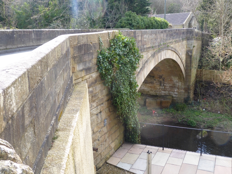
NZ 05 SE CONSETT RIVER DERWENT
5/76 (inset) Shotley Bridge
6/6/51
II
Bridge. Late C18, widened c.1820. Squared stone, lower parts of jambs and
north-east approach wall rock-faced stone. Elliptical arch. Earlier south
face shows recessed voussoirs and band below parapet; abutments splayed more
broadly than approach walls. North face of arch shows flush voussoirs and arch
ring. Parapets with chamfered coping; north-west wing wall runs to pier with
low pyramidal cap.
Part of this bridge is in the County of Northumberland.
Listing NGR: NZ 09081 52744
External links are from the relevant listing authority and, where applicable, Wikidata. Wikidata IDs may be related buildings as well as this specific building. If you want to add or update a link, you will need to do so by editing the Wikidata entry.


Other nearby listed buildings
