Approximate Location Map
Large Map »
Latitude: 51.2803 / 51°16'49"N
Longitude: 1.0799 / 1°4'47"E
OS Eastings: 614893
OS Northings: 157969
OS Grid: TR148579
Mapcode National: GBR TY2.PVT
Mapcode Global: VHLGM.N2SV
Plus Code: 9F3373JH+4X
Entry Name: 5 and 6, Orange Street
Listing Date: 7 September 1973
Grade: II
Source: Historic England
Source ID: 1241374
English Heritage Legacy ID: 440409
ID on this website: 101241374
Location: Canterbury, Kent, CT1
County: Kent
District: Canterbury
Electoral Ward/Division: Westgate
Parish: Non Civil Parish
Built-Up Area: Canterbury
Traditional County: Kent
Lieutenancy Area (Ceremonial County): Kent
Tagged with: Building
1.
944 ORANGE STREET
(South East Side)
Nos 5 and 6
TR 1457 NE 4/622
II GV
2.
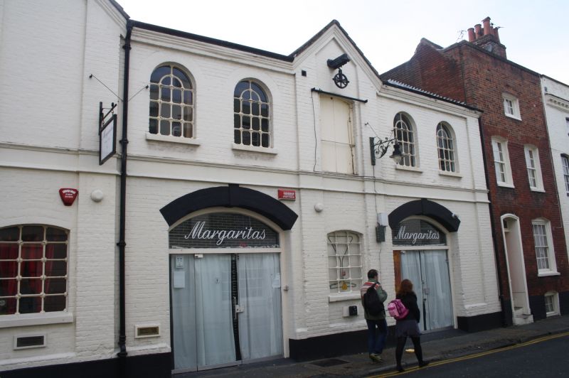
A C19 industrial building. 2 storeys red brick. Restored pantiled roof with
2 pedimented projections. 6 round-headed casements with metal glazing in
grouped in 2s, separated by pilasters. 1st floor has a pulley and trap door.
Ground floor has 2 cambered arches and a carriage entrance.
No 1 and Nos 4 to 7 (consec) form a group.
Listing NGR: TR1488857974
External links are from the relevant listing authority and, where applicable, Wikidata. Wikidata IDs may be related buildings as well as this specific building. If you want to add or update a link, you will need to do so by editing the Wikidata entry.


Other nearby listed buildings
