Approximate Location Map
Large Map »
Latitude: 51.282 / 51°16'55"N
Longitude: 1.071 / 1°4'15"E
OS Eastings: 614261
OS Northings: 158132
OS Grid: TR142581
Mapcode National: GBR TY2.FMM
Mapcode Global: VHLGM.J11J
Plus Code: 9F3373JC+R9
Entry Name: 18 and 19, Orchard Street
Listing Date: 7 September 1973
Grade: II
Source: Historic England
Source ID: 1241384
English Heritage Legacy ID: 440423
ID on this website: 101241384
Location: St Dunstan's, Canterbury, Kent, CT2
County: Kent
District: Canterbury
Electoral Ward/Division: Westgate
Parish: Non Civil Parish
Built-Up Area: Canterbury
Traditional County: Kent
Lieutenancy Area (Ceremonial County): Kent
Tagged with: Building
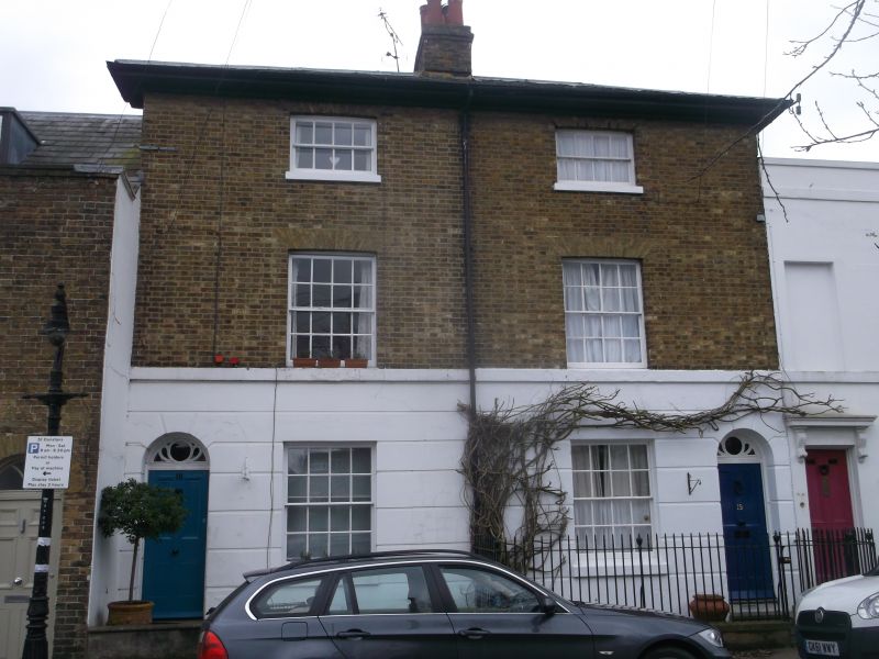
1.
944 ORCHARD STREET
(South East Side)
Nos 18 and 19
TR 1458 SW 1/633
II GV
2.
Early C19, 3 storeys buff brick with rusticated stuccoed ground floor. Slate
roof. Wide modillion cornice. 1 sash each. Stringcourse. 2 round-headed
doorcases with 4 panelled doors. No 18 has a later Victorian 4 light bays
Nos 1B to 25 (consec) form a group.
Listing NGR: TR1426458133
External links are from the relevant listing authority and, where applicable, Wikidata. Wikidata IDs may be related buildings as well as this specific building. If you want to add or update a link, you will need to do so by editing the Wikidata entry.


Other nearby listed buildings
