Approximate Location Map
Large Map »
Latitude: 51.2802 / 51°16'48"N
Longitude: 1.0809 / 1°4'51"E
OS Eastings: 614961
OS Northings: 157959
OS Grid: TR149579
Mapcode National: GBR TY2.Q2Q
Mapcode Global: VHLGM.P29Y
Plus Code: 9F3373JJ+39
Entry Name: 55 and 56, Palace Street
Listing Date: 7 September 1973
Grade: II
Source: Historic England
Source ID: 1241506
English Heritage Legacy ID: 440579
ID on this website: 101241506
Location: Canterbury, Kent, CT1
County: Kent
District: Canterbury
Electoral Ward/Division: Westgate
Parish: Non Civil Parish
Built-Up Area: Canterbury
Traditional County: Kent
Lieutenancy Area (Ceremonial County): Kent
Tagged with: Building
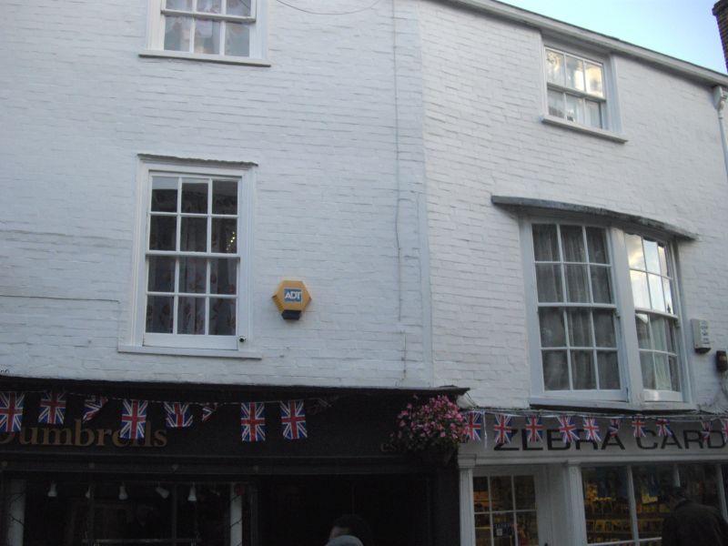
1. PALACE STREET
944 (East Side)
TR 1457 NE 4/52 Nos 55 and 56
II GV
2.
Cl8. 3 storeys painted brick. Old tiled roof. 1 sash each. No 56 has a
double-hung sash on 1st floor. C19 shopfront.
Nos 50 to 61 (consec) form a group together with Nos 14 to 24 (consec) Sun Street.
Listing NGR: TR1496357960
External links are from the relevant listing authority and, where applicable, Wikidata. Wikidata IDs may be related buildings as well as this specific building. If you want to add or update a link, you will need to do so by editing the Wikidata entry.


Other nearby listed buildings
