Approximate Location Map
Large Map »
Latitude: 53.7071 / 53°42'25"N
Longitude: -0.6353 / 0°38'6"W
OS Eastings: 490181
OS Northings: 424268
OS Grid: SE901242
Mapcode National: GBR ST0K.8V
Mapcode Global: WHGFT.62RX
Plus Code: 9C5XP947+RV
Entry Name: The Grove
Listing Date: 17 October 1985
Grade: II
Source: Historic England
Source ID: 1241773
English Heritage Legacy ID: 441004
ID on this website: 101241773
Location: Whitton, North Lincolnshire, DN15
County: North Lincolnshire
Civil Parish: Whitton
Traditional County: Lincolnshire
Lieutenancy Area (Ceremonial County): Lincolnshire
Church of England Parish: Whitton St John the Baptist
Church of England Diocese: Lincoln
Tagged with: Architectural structure
SE 92 SW WHITTON MAIN STREET STREET
(west side)
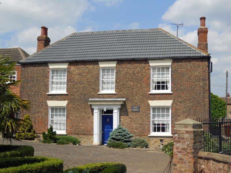
2/28 The Grove
GV II
Farmhouse. C18 or earlier origins, raised and re-fronted in later C18,
front altered and rear extension added mid-late C19. Brick front with sides
and rear of coursed limestone rubble with brick dressings; C19 rear section
in brick. Slate roof to front, concrete tiles to rear. Square on plan:
earlier L-shaped section with central entrance hall front range and later
infill in angle. Front at right angles to street: 2 storeys, 3 bays,
symmetrical. C19 Doric doorcase with pilasters supporting plain entablature
and hood. Panelled door and 3-pane overlight in panelled reveal. Sashes
with glazing bars under channelled stucco cambered arches: first floor
central 12-pane sash in original opening, others widened in C19 to 16-pane.
lipped roof; C19 end stacks. Right return facing street has two 16-pane
sashes under segmental arches. Adjoining C19-C20 ranges set back to left,
now offices and part of house, of no special interest.
Listing NGR: SE9018124268
External links are from the relevant listing authority and, where applicable, Wikidata. Wikidata IDs may be related buildings as well as this specific building. If you want to add or update a link, you will need to do so by editing the Wikidata entry.


Other nearby listed buildings
