Approximate Location Map
Large Map »
Latitude: 51.0687 / 51°4'7"N
Longitude: -1.7971 / 1°47'49"W
OS Eastings: 414315
OS Northings: 129946
OS Grid: SU143299
Mapcode National: GBR 517.VWY
Mapcode Global: FRA 7639.CPK
Plus Code: 9C3W3693+F5
Entry Name: 48-52, Silver Street
Listing Date: 28 February 1952
Grade: II*
Source: Historic England
Source ID: 1243171
English Heritage Legacy ID: 446741
ID on this website: 101243171
Location: Salisbury, Wiltshire, SP1
County: Wiltshire
Civil Parish: Salisbury
Built-Up Area: Salisbury
Traditional County: Wiltshire
Lieutenancy Area (Ceremonial County): Wiltshire
Church of England Parish: Salisbury St Thomas and St Edmund
Church of England Diocese: Salisbury
Tagged with: Building
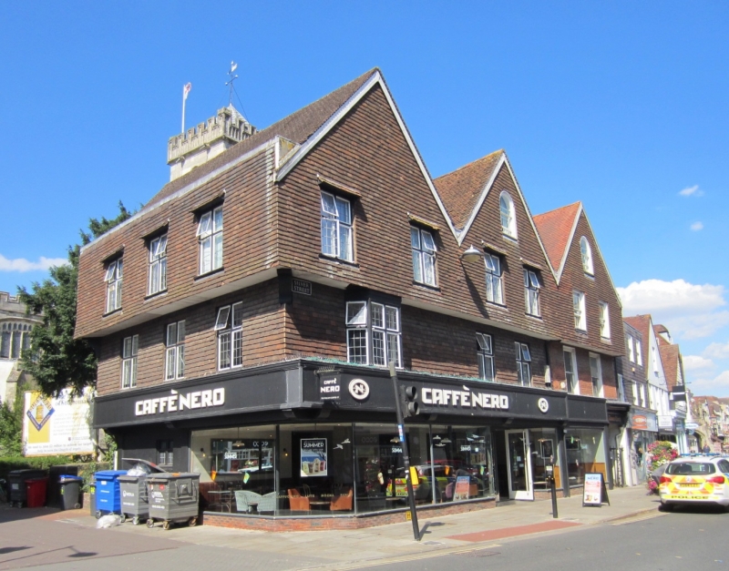
SILVER STREET
1.
1429 (North Side)
Nos 48 to 52 (even)
SU 1429 NW 3/320 28.2.52.
II* GV
2.
C15/C16 4 storeys triple gabled front. Timber frame with second floor oversailing.
No 48 has tile hung second floor, mathematical tiles to first floor. Nos 50
- 52 formerly stuccoed and tile hung with modern 2 light transomed leaded casements
and canted bay. No 48 has one window in gable .and 2 on first and second floors,
flush framed sashes, round headed in gable. Modern shop fronts. To right
hand of No 48 is passage entry to St Thomas's Church Yard and the south porch
of Church. The entry is framed by stout Doric pilasters carrying a 3 centred
arch with moulded architrave and moulded and scrolled keystone, painted, plain
wrought iron gates, all early C18. Similar archway to rear, facing church,
with plain Cl8 rails extending out each side. Rear elevations, modern tile
hanging to Nos 50 and 52, earlier to No 48 which has flush framed sashes.
The passage roof has exposed beans. Dragon beam to first floor No 52. Roof
structure partly intact.
The Poultry Cross and Nos 36 to 52 (even) form a group. The rear elevations
of Nos 1 to 17 (odd) Minster Street form a group with the rear elevations of
Nos 36 to 52 (even) and with St Thomas's Church, St Thomas's Square.
Listing NGR: SU1432129946
External links are from the relevant listing authority and, where applicable, Wikidata. Wikidata IDs may be related buildings as well as this specific building. If you want to add or update a link, you will need to do so by editing the Wikidata entry.


Other nearby listed buildings
