Latitude: 51.2744 / 51°16'27"N
Longitude: 0.1287 / 0°7'43"E
OS Eastings: 548580
OS Northings: 154953
OS Grid: TQ485549
Mapcode National: GBR LLQ.3C6
Mapcode Global: VHHPR.57WF
Plus Code: 9F3274FH+PF
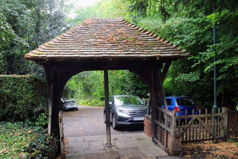
Entry Name: Lych Gate to West of Church of St Mary
Listing Date: 16 January 1975
Grade: II
Source: Historic England
Source ID: 1243762
English Heritage Legacy ID: 448037
ID on this website: 101243762
Location: Sundridge, Sevenoaks, Kent, TN14
County: Kent
District: Sevenoaks
Civil Parish: Sundridge with Ide Hill
Built-Up Area: Sundridge
Traditional County: Kent
Lieutenancy Area (Ceremonial County): Kent
Church of England Parish: Sundridge St Mary
Church of England Diocese: Rochester
Tagged with: Lychgate
1. 5280 SUNDRIDGE SUNDRIDGE Church Road (East Side)
Lych Gate to West of Church of St Mary TQ 4854 33/1237
II
2. Timber lych gate with 2 wickets and hipped tiled roof. Foundation at one side brick, the other stone. Date uncertain.
Listing NGR: TQ4858054953
External links are from the relevant listing authority and, where applicable, Wikidata. Wikidata IDs may be related buildings as well as this specific building. If you want to add or update a link, you will need to do so by editing the Wikidata entry.


Other nearby listed buildings