Latitude: 53.849 / 53°50'56"N
Longitude: -2.1043 / 2°6'15"W
OS Eastings: 393237
OS Northings: 439198
OS Grid: SD932391
Mapcode National: GBR FRRX.7Z
Mapcode Global: WHB7S.NJ55
Plus Code: 9C5VRVXW+H7
Entry Name: Clapper Bridge
Listing Date: 23 April 1952
Grade: II*
Source: Historic England
Source ID: 1243829
English Heritage Legacy ID: 186419
Also known as: The Hall Bridge, Wycoller
Weavers' Bridge
ID on this website: 101243829
Location: Wycoller, Pendle, Lancashire, BB8
County: Lancashire
District: Pendle
Civil Parish: Trawden Forest
Traditional County: Lancashire
Lieutenancy Area (Ceremonial County): Lancashire
Church of England Parish: Trawden St Mary
Church of England Diocese: Blackburn
Tagged with: Footbridge
SD 9339 TRAWDEN WYCOLLER ROAD
17/253 Clapper Bridge
23.4.52
- II*
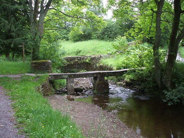
Also known as The Hall Bridge or Weavers' Bridge. Bridge, undateable, formed of
two stone slabs supported by central pier. Due to fracture of one of the
clappers a concrete pier has been added. Scheduled ancient monument.
Listing NGR: SD9323739198
External links are from the relevant listing authority and, where applicable, Wikidata. Wikidata IDs may be related buildings as well as this specific building. If you want to add or update a link, you will need to do so by editing the Wikidata entry.


Other nearby listed buildings