Approximate Location Map
Large Map »
Latitude: 51.891 / 51°53'27"N
Longitude: -2.0803 / 2°4'48"W
OS Eastings: 394573
OS Northings: 221386
OS Grid: SO945213
Mapcode National: GBR 2MB.GWH
Mapcode Global: VH947.WQMQ
Plus Code: 9C3VVWR9+CV
Entry Name: Numbers 16 and 17 and Attached Area Railings to Number 17
Listing Date: 14 December 1983
Grade: II
Source: Historic England
Source ID: 1245775
English Heritage Legacy ID: 474652
ID on this website: 101245775
Location: Montpellier, Cheltenham, Gloucestershire, GL50
County: Gloucestershire
District: Cheltenham
Electoral Ward/Division: Park
Parish: Non Civil Parish
Built-Up Area: Cheltenham
Traditional County: Gloucestershire
Lieutenancy Area (Ceremonial County): Gloucestershire
Church of England Parish: Leckhampton St Philip and St James
Church of England Diocese: Gloucester
Tagged with: Building
CHELTENHAM
SO9421SE GRATTON STREET
630-1/23/343 (South side)
14/12/83 Nos.16 AND 17
and attached area railings to No.17
II
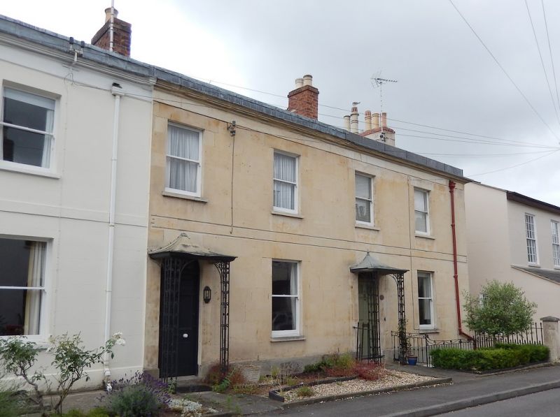
2 terraced houses and attached railings to No.17. c1830-40.
Ashlar over brick with concealed roof and end and party-wall
brick and stucco stacks with cornices; cast- and wrought-iron
porches and railings.
EXTERIOR: 2 storeys on basement, 4 first-floor windows.
First-floor incised double band. 1/1 sashes. Left entrances:
6-panel doors (that to right with 2 glazed panels) with
fanlights.
INTERIOR: not inspected.
SUBSIDIARY FEATURES: tent porches have scrolled uprights
embellished with leaves and tent roofs. Area railings have
embellished rods.
Listing NGR: SO9457621383
External links are from the relevant listing authority and, where applicable, Wikidata. Wikidata IDs may be related buildings as well as this specific building. If you want to add or update a link, you will need to do so by editing the Wikidata entry.


Other nearby listed buildings
