Approximate Location Map
Large Map »
Latitude: 53.3779 / 53°22'40"N
Longitude: -1.5038 / 1°30'13"W
OS Eastings: 433104
OS Northings: 386896
OS Grid: SK331868
Mapcode National: GBR 98L.2X
Mapcode Global: WHCCJ.WC29
Plus Code: 9C5W9FHW+5F
Entry Name: 17 and 19, Taptonville Road and Attached Boundary Wall and Railings
Listing Date: 28 June 1973
Last Amended: 12 December 1995
Grade: II
Source: Historic England
Source ID: 1247443
English Heritage Legacy ID: 456898
ID on this website: 101247443
Location: Summerfield, Sheffield, South Yorkshire, S10
County: Sheffield
Electoral Ward/Division: Broomhill and Sharrow Vale
Parish: Non Civil Parish
Built-Up Area: Sheffield
Traditional County: Yorkshire
Lieutenancy Area (Ceremonial County): South Yorkshire
Church of England Parish: Sheffield Broomhill St Mark
Church of England Diocese: Sheffield
Tagged with: Wall
SK3386NW
784-1/26/710
SHEFFIELD
TAPTONVILLE ROAD (South West side)
Nos.17 AND 19 and attached boundary wall and railings
(Formerly Listed as: TAPTONVILLE ROAD Nos 9 & 11, Nos 13 & 15, Nos 17 & 19)
28/06/73
GV
II
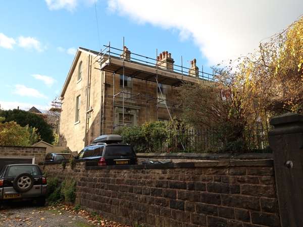
Two houses and adjoining wall and railing. c1850, with late C20 alterations. Ashlar with slate roof with three coped ridge stacks. Plinth, modillion wooden eaves. Two storeys plus garrets; six window range of twelve pane sashes with stone lintels. Below, four similar windows flanked by single moulded doorcases with bracketed cornices. Fielded six panel doors with plain overlights. Each gable has a single window, and above, a round-headed garret window.
INTERIOR not inspected.
Outside, adjoining coursed squared stone wall with chamfered coping and square gate piers with pyramidal caps. Spearhead cast-iron railing with two gateways.
Listing NGR: SK3310486896
External links are from the relevant listing authority and, where applicable, Wikidata. Wikidata IDs may be related buildings as well as this specific building. If you want to add or update a link, you will need to do so by editing the Wikidata entry.


Other nearby listed buildings
