Latitude: 53.1601 / 53°9'36"N
Longitude: -1.5933 / 1°35'35"W
OS Eastings: 427293
OS Northings: 362634
OS Grid: SK272626
Mapcode National: GBR 58H.S0M
Mapcode Global: WHCDG.HTJR
Plus Code: 9C5W5C64+3M
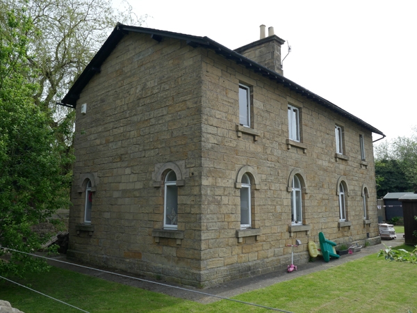
Entry Name: Darley Station Houses
Listing Date: 26 October 1972
Grade: II
Source: Historic England
Source ID: 1248234
English Heritage Legacy ID: 429807
ID on this website: 101248234
Location: Darley Dale, Derbyshire Dales, Derbyshire, DE4
County: Derbyshire
District: Derbyshire Dales
Civil Parish: Darley Dale
Built-Up Area: Matlock
Traditional County: Derbyshire
Lieutenancy Area (Ceremonial County): Derbyshire
Church of England Parish: Darley St Helen
Church of England Diocese: Derby
Tagged with: Architectural structure
1. STATION ROAD 1390 DARLEY DALE
Darley Station Houses SK 26 SE 10/91
II GV
2. Circa 1849. Built by Joseph Paxton and originally a pair of houses, later converted to one dwelling. Stone; 2 storeys; plain gable; 2 windows to ground floor with semi-circular heads and a blocked doorway between. South side has 4 windows fitted with modern casements and 4 lowers with semi-circular heads, the centrals of 2 lights; plain bold eaves; stone stacks; slates.
Darleydale Station, building on north platform and Station Houses form a group.
Listing NGR: SK2729362634
External links are from the relevant listing authority and, where applicable, Wikidata. Wikidata IDs may be related buildings as well as this specific building. If you want to add or update a link, you will need to do so by editing the Wikidata entry.


Other nearby listed buildings