Latitude: 54.9379 / 54°56'16"N
Longitude: -1.595 / 1°35'42"W
OS Eastings: 426043
OS Northings: 560430
OS Grid: NZ260604
Mapcode National: GBR KC9B.GQ
Mapcode Global: WHC3Y.G4PW
Plus Code: 9C6WWCQ3+4X
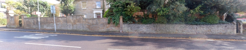
Entry Name: Forecourt Walls and Gate Piers to Numbers 123 and 125
Listing Date: 13 January 1983
Grade: II
Source: Historic England
Source ID: 1248563
English Heritage Legacy ID: 430230
ID on this website: 101248563
Location: Low Fell, Gateshead, Tyne and Wear, NE9
County: Gateshead
Electoral Ward/Division: Low Fell
Parish: Non Civil Parish
Built-Up Area: Gateshead
Traditional County: Durham
Lieutenancy Area (Ceremonial County): Tyne and Wear
Church of England Parish: Gateshead Fell
Church of England Diocese: Durham
Tagged with: Wall
1. KELLS LANE 5099 (east side)
NZ 2660 11/95 Forecourt Wall and Gate Piers to Nos 123 II TC and 125
2. Mid C19. Squared stone. Two pairs of gate piers, one for carriage entrance, one for footway: square, with plinth, projecting cornice and blocking course, pyramidal top. Included for group considerations.
Listing NGR: NZ2604360430
External links are from the relevant listing authority and, where applicable, Wikidata. Wikidata IDs may be related buildings as well as this specific building. If you want to add or update a link, you will need to do so by editing the Wikidata entry.


Other nearby listed buildings