Approximate Location Map
Large Map »
Latitude: 52.8752 / 52°52'30"N
Longitude: -1.1324 / 1°7'56"W
OS Eastings: 458487
OS Northings: 331209
OS Grid: SK584312
Mapcode National: GBR 8JK.NJ7
Mapcode Global: WHDH5.KZYP
Plus Code: 9C4WVVG9+32
Entry Name: Wesleyan Methodist Chapel
Listing Date: 13 November 1986
Grade: II
Source: Historic England
Source ID: 1248690
English Heritage Legacy ID: 430413
ID on this website: 101248690
Location: Bradmore, Rushcliffe, Nottinghamshire, NG11
County: Nottinghamshire
District: Rushcliffe
Civil Parish: Bradmore
Traditional County: Nottinghamshire
Lieutenancy Area (Ceremonial County): Nottinghamshire
Tagged with: Chapel
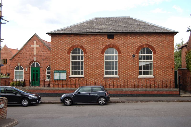
BRADMORE FARMER STREET
SK 53 SE (east side)
Wesleyan Methodist
5/8 Chapel
G.V. II
Chapel. c.1830. Red brick stretchers with pink headers. Hipped
slate roof. Single C19 red brick stack to the left. Single
storey, 3 bays. 3 round arched glazing bar casements. Attached
to the left is a 1904 wing is not of special interest.
Listing NGR: SK5848731209
External links are from the relevant listing authority and, where applicable, Wikidata. Wikidata IDs may be related buildings as well as this specific building. If you want to add or update a link, you will need to do so by editing the Wikidata entry.


Other nearby listed buildings
