Approximate Location Map
Large Map »
Latitude: 51.1713 / 51°10'16"N
Longitude: 0.2474 / 0°14'50"E
OS Eastings: 557212
OS Northings: 143741
OS Grid: TQ572437
Mapcode National: GBR MPC.HCL
Mapcode Global: VHHQ6.7TNG
Plus Code: 9F3256CW+GX
Entry Name: Bidborough Ridge Cottage
Listing Date: 24 August 1990
Grade: II
Source: Historic England
Source ID: 1248824
English Heritage Legacy ID: 430571
ID on this website: 101248824
Location: Bidborough, Tunbridge Wells, Kent, TN4
County: Kent
District: Tunbridge Wells
Civil Parish: Bidborough
Built-Up Area: Southborough
Traditional County: Kent
Lieutenancy Area (Ceremonial County): Kent
Church of England Parish: St Peter with Christ Church and St Matthew Southborough and St Lawrence Bidborough
Church of England Diocese: Rochester
Tagged with: Cottage
TQ 54 SE BIDBOROUGH BIDBOROUGH RIDGE
4/1 Bidborough Ridge Cottage
II
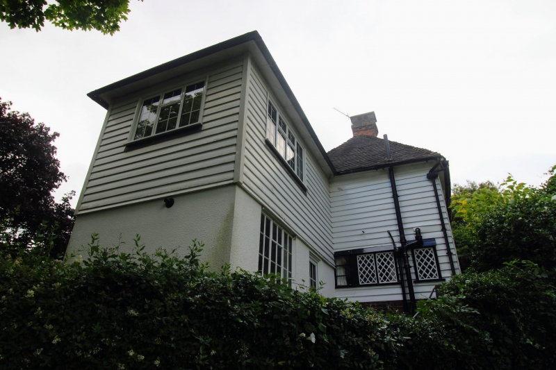
House. Circa late C17/early C18 with a 1940s rear wing-and a 1970s addition
on the left (west) end. Timber-framed construction, weatherbGirded on the
front elevation, the rear elevation tile-hung to the first floor above a 1940s
outshut; peg-tile roof; brick.stacks, 1940s addition brick and tile; 1970s
addition weatherboarded to the first floor, rendered below.
Plan: Overall L plan. The south-facing early range is single depth, 3 rooms
wide with what may be an original outshut at the right end. The 1940s
addition is a rear right (north east) wing at right angles to the main range;
the 1970s addition adjoins the early range at the left (west) end and is
slightly set back from it. 1940s rear left outshut to the main range. The
early range has end stacks (left end stack truncated) and an axial stack
(fireplace blocked), the position of the original entrance is unclear but may
have been to the right of centre where there is now a small window in the
front elevation. The right hand room was the kitchen, the fireplace had a
bread oven (information from owners), the outshut probably a pantry.
Exterior: 2 storeys. Asymmetrical 3 window front plus one window to the
outshut. Roof hipped at the left end and gabled at the right end; right hand
stack to the main range with a handmade brick shaft. 3 first floor and 3
ground floor one-, 2 and 3-light cast iron casement windows, probably dating
from the early C19. The one-light window on the ground floor may mark the
position of the original front door.
Interior: Parts of the frame are visible internally, especially in the right
hand (east) room, which has had the first floor removed and is now single-
storey but ceiled below the apex. There are straight up braces from the
middle rail to the wall plate and iron strapped joints to the cross
partitions. The front wall post of the first partition from the left (west)
has a chamfered, tapered, jowl; there is evidence of an original former window
on the rear wall, first floor, which is now enclosed by the 1940s wing. The
centre ground floor room has exposed joists.
Listing NGR: TQ5561443712
External links are from the relevant listing authority and, where applicable, Wikidata. Wikidata IDs may be related buildings as well as this specific building. If you want to add or update a link, you will need to do so by editing the Wikidata entry.


Other nearby listed buildings
