Approximate Location Map
Large Map »
Latitude: 51.0724 / 51°4'20"N
Longitude: -1.7963 / 1°47'46"W
OS Eastings: 414364
OS Northings: 130357
OS Grid: SU143303
Mapcode National: GBR 517.NND
Mapcode Global: FRA 7649.0A5
Plus Code: 9C3W36C3+WF
Entry Name: 95, Castle Street
Listing Date: 12 October 1972
Grade: II
Source: Historic England
Source ID: 1249061
English Heritage Legacy ID: 318915
ID on this website: 101249061
Location: Salisbury, Wiltshire, SP1
County: Wiltshire
Civil Parish: Salisbury
Built-Up Area: Salisbury
Traditional County: Wiltshire
Lieutenancy Area (Ceremonial County): Wiltshire
Church of England Parish: Salisbury St Thomas and St Edmund
Church of England Diocese: Salisbury
Tagged with: Building
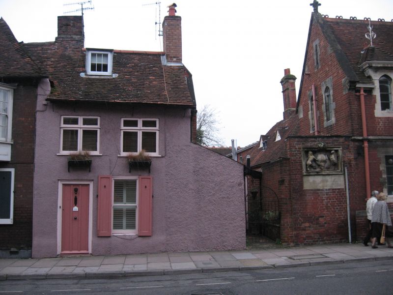
CASTLE STREET
1.
1594
(West Side)
No 95
SU 1430 SW 1/409
II GV
2.
C17/C18. 2 storey roughcast front. Steep pitch gable end old tile roof,
rafter ends projecting. Flat roofed dormer. 2 windows lst floor, one on
ground floor. 2 C19 casements and on ground floor flush framed sash, later
glazing. Door, in plain surround, of 4 flush panels, 2 glazed. The north
gable end has exposed early C18 stud framing with brick infilling.
Nos 77 to 87 (odd), No 2 Avon View and Nos 91 to 95 (odd) form a group.
Listing NGR: SU1436430357
External links are from the relevant listing authority and, where applicable, Wikidata. Wikidata IDs may be related buildings as well as this specific building. If you want to add or update a link, you will need to do so by editing the Wikidata entry.


Other nearby listed buildings
