Approximate Location Map
Large Map »
Latitude: 53.0661 / 53°3'57"N
Longitude: -2.5205 / 2°31'13"W
OS Eastings: 365221
OS Northings: 352222
OS Grid: SJ652522
Mapcode National: GBR 7T.BSBT
Mapcode Global: WH9BB.8619
Plus Code: 9C5V3F8H+CR
Entry Name: 32 and 34, Hospital Street
Listing Date: 1 March 1974
Grade: II
Source: Historic England
Source ID: 1249254
English Heritage Legacy ID: 431045
ID on this website: 101249254
Location: Nantwich, Cheshire East, Cheshire, CW5
County: Cheshire East
Civil Parish: Nantwich
Built-Up Area: Nantwich
Traditional County: Cheshire
Lieutenancy Area (Ceremonial County): Cheshire
Church of England Parish: Nantwich St Mary
Church of England Diocese: Chester
Tagged with: Shop
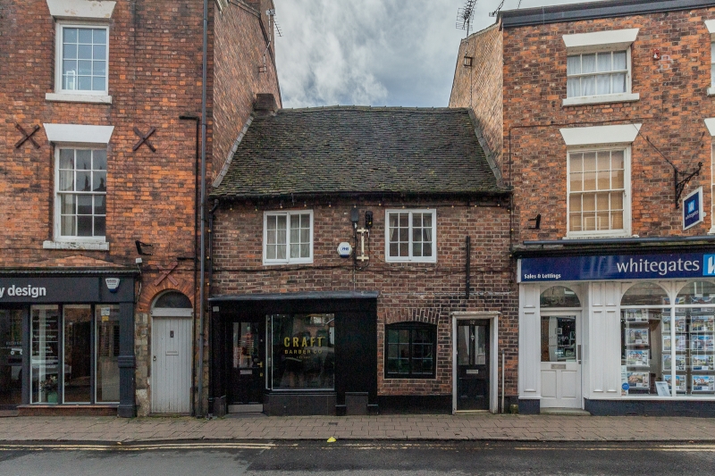
1.
1425 HOSPITAL STREET
(South Side)
---------------
Nos 32 and 34
SJ 6552 1/104
II GV
2.
Early Cl9 red brick to earlier timber frame; 2 storeys; 2 casement; windows; plain
doorway. C19 shop front to No 34.
Nos 20 to 28 (even), 30 to 42 (even) and No 46 form a group.
Listing NGR: SJ6522152222
External links are from the relevant listing authority and, where applicable, Wikidata. Wikidata IDs may be related buildings as well as this specific building. If you want to add or update a link, you will need to do so by editing the Wikidata entry.


Other nearby listed buildings
