Approximate Location Map
Large Map »
Latitude: 51.2524 / 51°15'8"N
Longitude: 0.4833 / 0°28'59"E
OS Eastings: 573394
OS Northings: 153286
OS Grid: TQ733532
Mapcode National: GBR PRC.H05
Mapcode Global: VHJMD.BSC9
Plus Code: 9F327F2M+X8
Entry Name: Church Hall
Listing Date: 20 December 1983
Grade: II
Source: Historic England
Source ID: 1249627
English Heritage Legacy ID: 431836
ID on this website: 101249627
Location: East Farleigh, Maidstone, Kent, ME15
County: Kent
District: Maidstone
Civil Parish: East Farleigh
Traditional County: Kent
Lieutenancy Area (Ceremonial County): Kent
Church of England Parish: East Farleigh
Church of England Diocese: Rochester
Tagged with: Church hall
LOWER ROAD
TQ 75 SW EAST FARLEIGH
(North Side)
2/45 Church Hall
20.12.1983
GV II
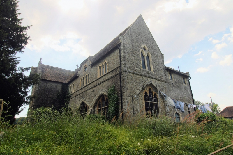
National school, now church hall. Mid C19 (by 1866), by J. Clarke.
Uncoursed ragstone with ashlar dressings and plain tile roof. Built at
right-angles to road. Front gable end with short, slightly recessed wing to
right. Further short wing towards rear, to long left side. 2 storeys, on
chamfered stone plinth. 2 moulded stone string courses forming band
between storeys to gable end, and one, lower, to right wing. Lower eaves
to right wing. Stone-coped and kneelered gable with angled projections and
fleur-de-lys finial. Similar gables to wings. Slightly projecting stone
stack in angle with left wing. Tall window of 3 cusped lights with sexfoil
and hoodmould. Ground-floor window of 3 stepped lights in moulded pointed-
arched recess. First-floor window to wing of 3 stepped Caernavon-arched
lights. Cusped lancet to ground-floor. Slightly recessed stone lean-to
to left with boarded door. Taller doorway to right wing. Bell-cote to right
gable end. Right return elevation of main range has four ground-floor
windows similar to ground-floor window of gable end, alternating with
buttresses, groups of lancets to first-floor, and central dormer. 2-storey
turret to north-west, linked by cat-walk. Interior not inspected. Replaced
a school by Butterfield, built in 1846. (J. Newman, B.O.E. Series, West
Kent and the Weald,1980).
Listing NGR: TQ7291753345
External links are from the relevant listing authority and, where applicable, Wikidata. Wikidata IDs may be related buildings as well as this specific building. If you want to add or update a link, you will need to do so by editing the Wikidata entry.


Other nearby listed buildings
