Approximate Location Map
Large Map »
Latitude: 51.7155 / 51°42'55"N
Longitude: -2.5324 / 2°31'56"W
OS Eastings: 363313
OS Northings: 201997
OS Grid: SO633019
Mapcode National: GBR JT.31PJ
Mapcode Global: VH87J.242Q
Plus Code: 9C3VPF89+52
Entry Name: Former Severn and Wye Railway Tramway Bridge
Listing Date: 26 August 1994
Grade: II
Source: Historic England
Source ID: 1249702
English Heritage Legacy ID: 431906
ID on this website: 101249702
Location: Tutnalls, Forest of Dean, Gloucestershire, GL15
County: Gloucestershire
District: Forest of Dean
Civil Parish: Lydney
Built-Up Area: Lydney
Traditional County: Gloucestershire
Lieutenancy Area (Ceremonial County): Gloucestershire
Church of England Parish: Lydney St Mary the Virgin
Church of England Diocese: Gloucester
Tagged with: Tram bridge
The following building shall be added to the list:-
LYDNEY STATION ROAD
SO 60 SW
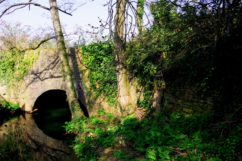
7/10001 Former Severn and Wye
Railway Tramway
Bridge
- II
Tramway bridge. Built c1810 for Lydney and Lydbrook Canal Company (later Severn and Wye
Railway). Squared and coursed stone with ashlar parapet, set on a curved alignment with
voussoirs to semi-circular arch. A complete and rare example of a structure associated with a
horse-drawn tramway, preceding the introduction of steam-powered locomotion. The tramroad
was built to improve the export of Forest of Dean coal, both up the Wye to Hereford and to the
Thames Valley via the basin at Lydney and the Severn.
(Hadfield C, The Canals of South Wales and The Border, Cardiff, 1967, pp 208-17)
Listing NGR: SO6331301997
External links are from the relevant listing authority and, where applicable, Wikidata. Wikidata IDs may be related buildings as well as this specific building. If you want to add or update a link, you will need to do so by editing the Wikidata entry.


Other nearby listed buildings
