Approximate Location Map
Large Map »
Latitude: 54.6857 / 54°41'8"N
Longitude: -1.2095 / 1°12'34"W
OS Eastings: 451062
OS Northings: 532586
OS Grid: NZ510325
Mapcode National: GBR MGZ8.Y2
Mapcode Global: WHD6F.DH95
Plus Code: 9C6WMQPR+76
Entry Name: Christ Church
Listing Date: 10 November 1982
Grade: II*
Source: Historic England
Source ID: 1250112
English Heritage Legacy ID: 432343
ID on this website: 101250112
Location: Hartlepool, County Durham, TS24
County: Hartlepool
Electoral Ward/Division: Headland and Harbour
Parish: Non Civil Parish
Built-Up Area: Hartlepool
Traditional County: Durham
Lieutenancy Area (Ceremonial County): County Durham
Church of England Parish: Stranton
Church of England Diocese: Durham
Tagged with: Church building
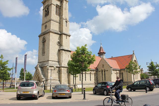
HARTLEPOOL CHURCH SQUARE
NZ 5132
(in middle of road)
11/48
Christ Church
10.11.82
G.V. II*
Church, now redundant, 1850-54 by E.B. Lamb (London). Rockfaced, snecked
limestone; plain clay tile roofs. Quasi Early English style. Aisled nave,
transepts, aisled and ½-octagonal apsed chancel; vestries in angles of nave
and transepts; and west tower. 4-stage tower, 2nd and 3rd stages being
deeply set back behind broad chamfered string courses; high battered parapet
on corbel table, has pierced balustrade. Vice at south-east angle rises
above tower as turret having splay-footed spirelet. Clock mechanism by W.
Potts (Leeds) 1911, with faces applied to belfry openings on north, east and
west faces. Porch to west side of tower. Early English style to windows
and other details generally. Rose windows to transept gables. Tripartite
east window. Crossing lit by octagonal timber lantern with tiled,
sprocketed, low-pitched fleche. Good stained glass in chancel and transept
windows. Most internal fittings removed, except for west gallery of wood,
and octagonal oak pulpit on carved stone pedestal. Disused at time of
survey.
Listing NGR: NZ5106932586
External links are from the relevant listing authority and, where applicable, Wikidata. Wikidata IDs may be related buildings as well as this specific building. If you want to add or update a link, you will need to do so by editing the Wikidata entry.


Other nearby listed buildings
