Latitude: 53.6427 / 53°38'33"N
Longitude: -2.3205 / 2°19'13"W
OS Eastings: 378907
OS Northings: 416289
OS Grid: SD789162
Mapcode National: GBR DV79.DX
Mapcode Global: WH97J.BP7T
Plus Code: 9C5VJMVH+3Q
Entry Name: Church of St Andrew
Listing Date: 8 January 1993
Grade: II
Source: Historic England
Source ID: 1250813
English Heritage Legacy ID: 433291
Also known as: St Andrew's Church, Ramsbottom
ID on this website: 101250813
Location: St Andrew's Church, Tagg Wood, Bury, Greater Manchester, BL0
County: Bury
Electoral Ward/Division: Ramsbottom
Parish: Non Civil Parish
Built-Up Area: Ramsbottom
Traditional County: Lancashire
Lieutenancy Area (Ceremonial County): Greater Manchester
Church of England Parish: Ramsbottom St Andrew
Church of England Diocese: Manchester
Tagged with: Church building
The following building shall be added:
SD 71 NE BOLTON STREET
326-/3/10007 Church of St Andrew II
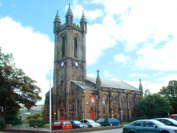
Anglican church, 1834, by Welsh of Birmingham, with early C20 alterations and additions. Regularly coursed, squared gritstone and ashlar gritstone, with ashlar dressings beneath a Welsh slate roof covering. Patron William Grant, and erected originally for Presbyterian worship which ceased in 1869. North-west tower with a lean-to porch to each side, wide nave without aisle arcades, and shallow polygonal apse to south-east end tower, square on plan, of two stages, above a basement. Polygonal buttresses, surmounted by squat pinnacles with stepped pyramidal caps. Shallow crenellated parapets link the pinnacles. North-west tower elevation with tall two-light lancet with deeply chamfered reveal, and 'Y' tracery joinery, interrupted by ashlar panel with blind quatrefoil. Hood mould to window head with plain stops. Plain smaller lancet above, with deeply chamfered reveal. First stage terminates at moulded string course penetrated by surround of diagonally-set clock face. Bell stage with tall louvred lancet of two lights, with deeply chamfered reveal, all below a hood mould. Lean-to lower porches with plain shallow parapets, stepped angle buttresses, and single lancets to end walls. Side wall entrances with steeply-arched heads and deeply chamfered reveals, quoined surrounds, and hood moulds with shield stops. Pointed arch- headed door with blind tracery to middle panels and 'Y' tracery to door head. Rectangular wall plaque above door head with coat of arms of the Grant family, the date of 1834 and the motto "CRAIG ELACHIE". North-east side wall of five bays, rising from a shallow chamfered plinth, the bays defined by stepped buttresses. The ends of the nave are defined by polygonal buttresses, which rise above eaves level, with tapering pinnacles with foliage finials. Each bay has a tall lancet window set within a deeply chamfered reveal, and with 'Y' traceried joinery. Plain corbel table, below shallow plain parapet. Shallow pentagonal apse, added early C20, replacing seven-light south- east window. Plain lancet to each apse facet. Interior retains original benches, with later covers to panelled backs, choir stalls with reading desk with open arcaded fronts. Octagonal pulpit of timber set on stone stem, relocated against north-east wall, and altar rail, both late C19. Reredos of 1920 in apse, with 3 late C20 stained glass windows, the central one depicting St Andrew. Gallery to north-west end, supported on two octagonal columns. Panelled front to gallery with cornice and top rail, blind arcading decoration to panels incorporates clock in centre, and lower cornice above wide-cusped blind arcading decoration below. Two access staircases from porches to gallery, each with stick balusters, turned newel posts, and access doorways with half glazed doors with margin lights. Seven wall monuments to the Grant family, industrialists involved in calico printing at Square Street Mill, Ramsbottom.
Listing NGR: SD7890716289
External links are from the relevant listing authority and, where applicable, Wikidata. Wikidata IDs may be related buildings as well as this specific building. If you want to add or update a link, you will need to do so by editing the Wikidata entry.


Other nearby listed buildings