Approximate Location Map
Large Map »
Latitude: 52.6738 / 52°40'25"N
Longitude: -0.9694 / 0°58'9"W
OS Eastings: 469779
OS Northings: 308957
OS Grid: SK697089
Mapcode National: GBR BPY.7QV
Mapcode Global: WHFKK.22M0
Plus Code: 9C4XM2FJ+G6
Entry Name: Gazebo 100 Metres South South West of Baggrave Hall
Listing Date: 25 September 1989
Grade: II
Source: Historic England
Source ID: 1251265
English Heritage Legacy ID: 355270
ID on this website: 101251265
Location: Harborough, Leicestershire, LE7
County: Leicestershire
District: Harborough
Civil Parish: Hungarton
Traditional County: Leicestershire
Lieutenancy Area (Ceremonial County): Leicestershire
Church of England Parish: Hungarton St John The Baptist
Church of England Diocese: Leicester
Tagged with: Gazebo
The following building shall be included:
SK 60 NE HUNGARTON Gazebo 100 metres SSW
of Baggrave Hall
2/90
II
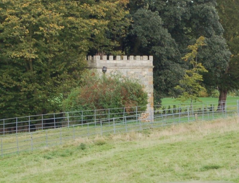
Gazebo. Probably c.1770s. Coursed ironstone and limestone rubble, ashlar lime-
stone to garden front (E). Simple square plan, single storey. Gothick in style
re-using some genuine medieval fragments. Garden front: central 4-centred arched
doorway (with wooden printed arches to tympanum and half-glazed double doors with
Gothick arches to lower panels) flanked by single-light pointed lancets with
wooden trefoil tracery. 3 sunken panels above with pierced tracery. External
stone steps with low walls with coping. Plinth. Moulded cornice band, parapet,
crenellation with pierced merlons continuous to all elevations, some merlons
missing. Simple lancet to either side wall. Rear with central moulded arched
doorway (plain tympanum and half-glazed doors) with a re-used medieval corbel head
above. A good example of late-C18 Gothick garden furniture.
Listing NGR: SK6977908957
External links are from the relevant listing authority and, where applicable, Wikidata. Wikidata IDs may be related buildings as well as this specific building. If you want to add or update a link, you will need to do so by editing the Wikidata entry.


Other nearby listed buildings
