Approximate Location Map
Large Map »
Latitude: 51.7545 / 51°45'16"N
Longitude: -0.336 / 0°20'9"W
OS Eastings: 514952
OS Northings: 207507
OS Grid: TL149075
Mapcode National: GBR H83.ZVV
Mapcode Global: VHGPQ.456C
Plus Code: 9C3XQM37+QH
Entry Name: The Cock Public House
Listing Date: 25 September 1989
Grade: II
Source: Historic England
Source ID: 1251280
English Heritage Legacy ID: 163522
Also known as: The Cock, St Albans
Cock
ID on this website: 101251280
Location: St Albans, St. Albans, Hertfordshire, AL1
County: Hertfordshire
District: St. Albans
Electoral Ward/Division: St Peters
Parish: Non Civil Parish
Built-Up Area: St Albans
Traditional County: Hertfordshire
Lieutenancy Area (Ceremonial County): Hertfordshire
Church of England Parish: St Albans St Peter
Church of England Diocese: St.Albans
Tagged with: Pub
TL 1407 NE
4/283
ST ALBANS
ST PETER'S STREET
(south east side)
Nos 48 and 50
(The Cock PH)
II
GV
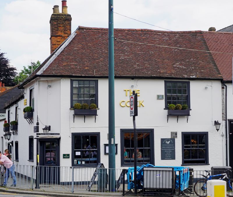
Public House. Late C16 or early C17, added to and altered. Painted brick
with 1st floor rendered on St Peter's Street side incorporating timber framing.
Plain tile roof. 2 timber-framed bays, jettied at front and left side, with
wing added to rear (C17), jetties underbuilt, 3rd bay added to front right
(probably early C19), and wing extended rearwards (C19 and C20). St Peter's
Street elevation: 2 1st-floor windows; left corner canted and having C20 door
with pub sign over; 3 large C20 sash windows to ground floor, of 6, 8 and
6 panes; on 1st floor, pub sign flanked by 16-pane sash windows. Roof hipped
at left end. Large brick stack to rear left. Left return: front range has
a window to each floor, the wing a door flanked by windows on each floor the
ground-floor openings cambered-headed; ground-floor windows are C20, small-
paned; 1st-floor windows are 2-light, 8-pane, side-sliding sashes; lower single-
wing-extension on left has three 6-pane sashes, parapet, and ridge stack.
Interior: timber-framed part of front range has chamfered cross-beam with
stepped cyma stop; broad, close-set, joists and dragon-beam at corner with
carpenters marks; covered-over timbers visible on 1st floor including jowelled
wall posts and tie-beams. Front part of rear wing (which is the oldest) has
chamfered spine-beam with run-out stops, and wall plate visible on 1st floor.
Listing NGR: TL1495207507
External links are from the relevant listing authority and, where applicable, Wikidata. Wikidata IDs may be related buildings as well as this specific building. If you want to add or update a link, you will need to do so by editing the Wikidata entry.


Other nearby listed buildings
