Approximate Location Map
Large Map »
Latitude: 54.5683 / 54°34'5"N
Longitude: -0.9962 / 0°59'46"W
OS Eastings: 464995
OS Northings: 519689
OS Grid: NZ649196
Mapcode National: GBR PHHM.35
Mapcode Global: WHF87.NFTR
Plus Code: 9C6XH293+8G
Entry Name: Skelton Mill Farmhouse and Remains of Mill
Listing Date: 8 September 1986
Grade: II
Source: Historic England
Source ID: 1251324
English Heritage Legacy ID: 432748
ID on this website: 101251324
Location: Redcar and Cleveland, North Yorkshire, TS12
County: Redcar and Cleveland
Civil Parish: Skelton and Brotton
Traditional County: Yorkshire
Lieutenancy Area (Ceremonial County): North Yorkshire
Church of England Parish: Skelton with Upleatham All Saints
Church of England Diocese: York
Tagged with: Farmhouse
NZ 61NW & NZ61 NE SKELTON & BROTTON MARSKE LANE
(east side), Skelton
2/29 Skelton Mill Farmouse
& 3/29 and remains of mill.
25.5.66
II
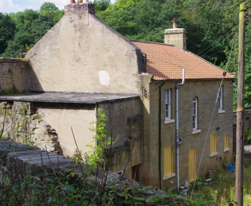
Farmhouse and remains of watermill, early/mid C19. Dressed sandstone with
tooled margins. Welsh slate roof with stone ridge and gable copings and
moulded kneelers. Concrete roof to remains of mill. Stone stack at left
end. 2 storeys, 3 windows. Central doorway has renewed boarded door,
overlight with geometric glazing bars and raised flat surround. Sashes with
glazing bars, that to right on first floor renewed. Painted stone sills.
Remains of mill, adjoining right, 3 storeys, one window. Wide flat-arched
opening with voussoirs, now blocked, on ground floor. Now holds boarded
door and overlight to left, and horizontal sash window with glazing bars to
right. Upper-floor windows blocked and painted to represent sashes with
glazing bars. Gable with stone coping, moulded kneeler and rebuilt brick
stack, rises above house to left of remains of mill. Flat roof between
first and second floors. Area wall with chamfered copings, ornamental iron
railings and gate, to front of house. Curved yard wall with curved copings
and boarded door, adjoins left of house. Rear elevation shows round-headed
stair window. Farm outbuildings to rear (north-west) are not of interest.
Mill partly destroyed by aerial bombardment in 1942.
Listing NGR: NZ6499519689
External links are from the relevant listing authority and, where applicable, Wikidata. Wikidata IDs may be related buildings as well as this specific building. If you want to add or update a link, you will need to do so by editing the Wikidata entry.


Other nearby listed buildings
