Approximate Location Map
Large Map »
Latitude: 51.5141 / 51°30'50"N
Longitude: -0.1076 / 0°6'27"W
OS Eastings: 531410
OS Northings: 181156
OS Grid: TQ314811
Mapcode National: GBR MC.ZF
Mapcode Global: VHGR0.26ZN
Plus Code: 9C3XGV7R+JX
Entry Name: Tipperary Public House
Listing Date: 28 January 1987
Grade: II
Source: Historic England
Source ID: 1251734
English Heritage Legacy ID: 434523
Also known as: The Tipperary, Fleet Street
Tipperary
ID on this website: 101251734
Location: Holborn, City of London, London, EC4Y
County: London
District: City and County of the City of London
Electoral Ward/Division: Castle Baynard
Parish: Non Civil Parish
Built-Up Area: City of London
Traditional County: Middlesex
Lieutenancy Area (Ceremonial County): City of London
Church of England Parish: St Bride Fleet Street
Church of England Diocese: London
Tagged with: Pub
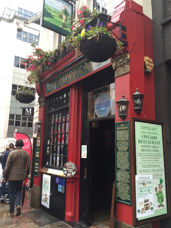
FLEET STREET
1.
5002
No. 66 (Tipperary P.H)
TQ 3181 SW 7/303
II
2.
Public house. Circa 1667, altered. Stuccoed brick. Roof not visible. 4
storeys plus attic. 2 bays. Early C20 pub front to ground floor. Square headed
architraved windows. Cornices above ground, first and third floor windows. Interior retains
early turned baluster staircase from second floor upwards.
Listing NGR: TQ3141381152
External links are from the relevant listing authority and, where applicable, Wikidata. Wikidata IDs may be related buildings as well as this specific building. If you want to add or update a link, you will need to do so by editing the Wikidata entry.


Other nearby listed buildings
