Approximate Location Map
Large Map »
Latitude: 53.1631 / 53°9'47"N
Longitude: -1.1935 / 1°11'36"W
OS Eastings: 454015
OS Northings: 363190
OS Grid: SK540631
Mapcode National: GBR 8DZ.R1R
Mapcode Global: WHDFS.MRVG
Plus Code: 9C5W5R74+6H
Entry Name: Sarcophagus 10 Metres South of South Porch at Church of St Edmund
Listing Date: 22 October 1986
Grade: II
Source: Historic England
Source ID: 1252004
English Heritage Legacy ID: 434663
ID on this website: 101252004
Location: St Edmund's Church, Mansfield Woodhouse, Mansfield, Nottinghamshire, NG19
County: Nottinghamshire
District: Mansfield
Electoral Ward/Division: Woodhouse
Parish: Non Civil Parish
Built-Up Area: Mansfield Woodhouse
Traditional County: Nottinghamshire
Lieutenancy Area (Ceremonial County): Nottinghamshire
Church of England Parish: Mansfield Woodhouse
Church of England Diocese: Southwell and Nottingham
Tagged with: Architectural structure
MANSFIELD WOODHOUSE CHURCH STREET
SK 5463 SW
(west side)
7/23 Sarcophagus lOM
south of south
porch at Church of
St. Edmund
G.V. II
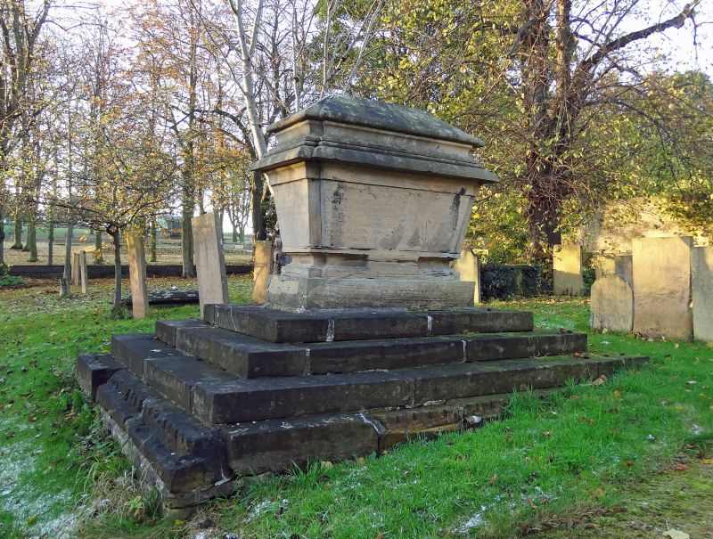
Sarcophagus. Mid C18. Ashlar. Rectangular base of 4 steps,
formerly with railing. Sarcophagus has rebated corners, moulded
top edge and hipped lid. Inscribed panels on three sides, mainly
illegible. West side has wreathed cartouche with Arms.
Listing NGR: SK5401563190
External links are from the relevant listing authority and, where applicable, Wikidata. Wikidata IDs may be related buildings as well as this specific building. If you want to add or update a link, you will need to do so by editing the Wikidata entry.


Other nearby listed buildings
