Latitude: 51.2276 / 51°13'39"N
Longitude: -2.8116 / 2°48'41"W
OS Eastings: 343421
OS Northings: 147919
OS Grid: ST434479
Mapcode National: GBR MF.2X3F
Mapcode Global: VH7D7.6DYQ
Plus Code: 9C3V65HQ+38
Entry Name: Boundary Wall, Gates, Gate Piers and Railings to the Grounds of Manor Cottage, Middle Manor and South Manor
Listing Date: 31 May 1985
Grade: II
Source: Historic England
Source ID: 1252779
English Heritage Legacy ID: 435885
ID on this website: 101252779
Location: Wedmore, Somerset, BS28
County: Somerset
District: Sedgemoor
Civil Parish: Wedmore
Built-Up Area: Wedmore
Traditional County: Somerset
Lieutenancy Area (Ceremonial County): Somerset
Tagged with: Wall
ST44NW
14/189
WEDMORE CP
PILCORN STREET (North side)
Boundary wall, gates, gate piers and railings to the grounds of Manor Cottage, Middle Manor and South Manor
GV
II
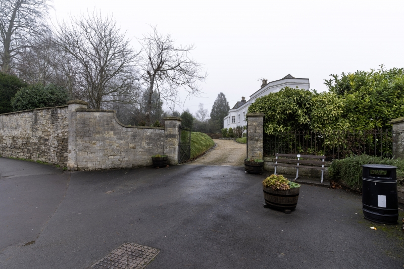
Boundary wall, gates, gate piers and railings. Early C19. Rubble wall extends for approximately 60 metres along the
East side of Lascot Hill, radiused at junction of Lascot Hill and Pilcorn Street, continues for a further 60 metres
along the North side of Pilcorn Street; further section of coursed and squared rubble wall at East end adjacent to
entrance to South Manor (qv); Wall varies in height between 2 and 4 metres, plain coping steeply ramped at junction of
Lascot Hill and Pilcorn Street. Gateway to South Manor with piers of coursed and squared rubble, moulded caps, paired
cast and wrought iron gates. Low wrought-iron railings continuing to East in a similar style for approximately 30
metres forming a boundary between the grounds of South Manor and the churchyard of the Church of St Mary (qv).
Primarily included for group value.
Listing NGR: ST4342147919
External links are from the relevant listing authority and, where applicable, Wikidata. Wikidata IDs may be related buildings as well as this specific building. If you want to add or update a link, you will need to do so by editing the Wikidata entry.


Other nearby listed buildings