Approximate Location Map
Large Map »
Latitude: 50.9126 / 50°54'45"N
Longitude: -1.4067 / 1°24'24"W
OS Eastings: 441808
OS Northings: 112740
OS Grid: SU418127
Mapcode National: GBR RQB.N1
Mapcode Global: FRA 76YP.FT3
Plus Code: 9C2WWH7V+28
Entry Name: 77, Bedford Place
Listing Date: 14 February 1969
Grade: II
Source: Historic England
Source ID: 1252953
English Heritage Legacy ID: 436074
ID on this website: 101252953
Location: Bedford Place, Southampton, Hampshire, SO15
County: City of Southampton
Electoral Ward/Division: Bargate
Parish: Non Civil Parish
Built-Up Area: Southampton
Traditional County: Hampshire
Lieutenancy Area (Ceremonial County): Hampshire
Church of England Parish: Southampton City Centre St Mary
Church of England Diocese: Winchester
Tagged with: Building
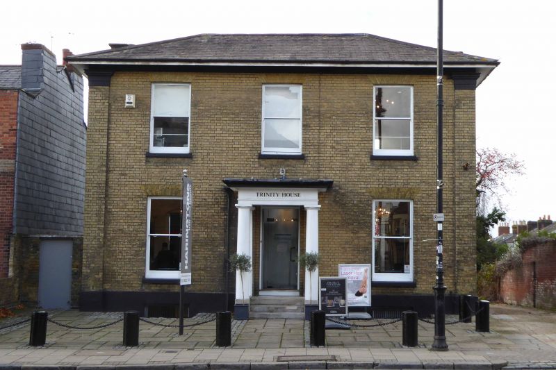
1. BEDFORD PLACE
5239 (west side)
No 77
SU 4112 1/24 14.2.69
II
GV
2.
Detached house early to mid-C19. Two storeys yellow brick. Hipped slate
roof with wide eaves cornice and end pilasters. Three sashes without glazing
bars. Central doorcase under oblong fanlight. Plain Doric portico.
Listing NGR: SU4255313582
External links are from the relevant listing authority and, where applicable, Wikidata. Wikidata IDs may be related buildings as well as this specific building. If you want to add or update a link, you will need to do so by editing the Wikidata entry.


Other nearby listed buildings
