Latitude: 51.0662 / 51°3'58"N
Longitude: -1.7979 / 1°47'52"W
OS Eastings: 414259
OS Northings: 129669
OS Grid: SU142296
Mapcode National: GBR 51F.297
Mapcode Global: FRA 7639.KDS
Plus Code: 9C3W3682+FV
Entry Name: 36A and 36B, the Close
Listing Date: 28 February 1952
Last Amended: 12 October 1952
Grade: II*
Source: Historic England
Source ID: 1253217
English Heritage Legacy ID: 319015
ID on this website: 101253217
Location: The Friary, Wiltshire, SP1
County: Wiltshire
Civil Parish: Salisbury
Built-Up Area: Salisbury
Traditional County: Wiltshire
Lieutenancy Area (Ceremonial County): Wiltshire
Tagged with: Building
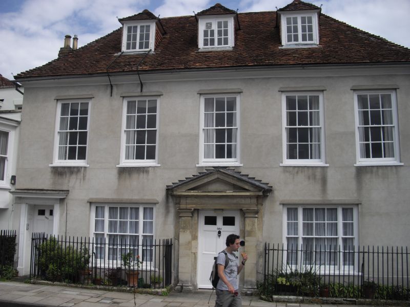
THE CLOSE
1.
1594
Nos 36A & 36B
(Formerly listed as No 36)
SU 1429 NW 3/29 28.2.52.
II* GV
2.
Mid C18 casing of earlier structure. 2 storeys and attic, stucco faced. Steep
hipped old tile roof. Coved and moulded eaves cornice. 3 hipped and tile
hung casement dormers. 5 windows 1st floor, flush architrave framed sashes,
glazing bars intact. 2 flush framed tripartite sashes on ground floor, glazing
bars, flanking central door of 6 fielded panels in wide stone Roman Doric
doorcase of pilasters entablature and pediment. Secondary door to left of
6 fielded panels, recessed with panelled reveals, doorcase of reeded pilasters,
rosette corner blocks and cornice over. Exposed ceiling beams on ground floor.
The south front to North Walk has 3 windows on 1st floor and 2 tripartite
sashes on ground, as on west front. Former central doorway or window, now
blocked.
All the listed buildings in the Close form an outstanding group.
Listing NGR: SU1425929669
External links are from the relevant listing authority and, where applicable, Wikidata. Wikidata IDs may be related buildings as well as this specific building. If you want to add or update a link, you will need to do so by editing the Wikidata entry.


Other nearby listed buildings