Latitude: 51.0669 / 51°4'0"N
Longitude: -1.7975 / 1°47'50"W
OS Eastings: 414286
OS Northings: 129752
OS Grid: SU142297
Mapcode National: GBR 51F.2C5
Mapcode Global: FRA 7639.KJV
Plus Code: 9C3W3683+Q2
Entry Name: 48 and 48A, The Close
Listing Date: 28 February 1952
Last Amended: 12 October 1972
Grade: II*
Source: Historic England
Source ID: 1253969
English Heritage Legacy ID: 319023
ID on this website: 101253969
Location: The Friary, Wiltshire, SP1
County: Wiltshire
Civil Parish: Salisbury
Built-Up Area: Salisbury
Traditional County: Wiltshire
Lieutenancy Area (Ceremonial County): Wiltshire
Church of England Parish: Salisbury St Thomas and St Edmund
Church of England Diocese: Salisbury
Tagged with: Building
This list entry was subject to a Minor Amendment on 21 April 2021 to reformat the text to current standards
SU 1429 NW
3/24
THE CLOSE
Nos 48 and 48A
(Formerly listed as No 48)
28.2.52.
GV
II*
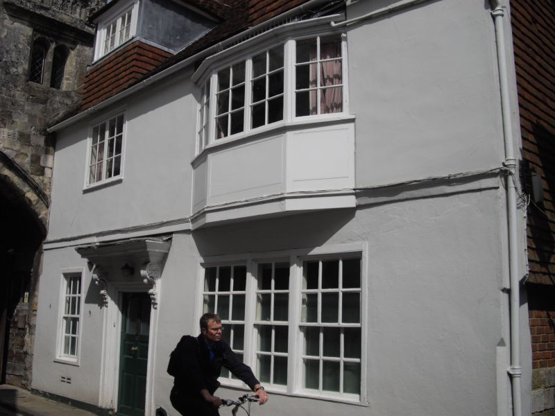
C14/C15 but recased C17 and C18. Two storeys and attic, stucco faced. Gable end old tile roof. Wood first floor string. Two large hipped dormers with C19 lights. First floor has late C18 casement to left and four-light canted bay to right (recently cut back) sash glazing bar lights, panelled apron. On ground floor two C18 windows flanking entrance, one a single sash the other tripartite, thick glazing bars; both with panelled shutters. Door off centre six panels, in architrave surround, plain frieze, panelled pilasters and carved scroll brackets supporting heavy moulded cornice, broken forward over brackets. The south gable end wall, in passage, has stone external chimney with offsets. Stone rubble and timber framed walling with brick infilling now rendered over. Tile hung part to rear. The east rear elevation has tile hung built out early C19 part but with old stone rubble base to left. Early C19 tripartite sash on first floor, blocked window on north side. The upper floor of the wing partly conceals pair of gables to main block one with timber framing. To the north and running east a lower partly timber framed wing, restored casements. North wing has various blocks of reused old Sarum stone with chevron and star carvings.
Interior has some remains of timber frame. Wall post in ground floor cloak room. Hall has beams and partition. Front living room has beams showing position of former overhang. In small front kitchen part of the wall of adjoining North Gate (qv) is exposed, stone and flint chequer, blocked doorway (formerly night watchman's entrance). On first floor south side room with C17 panelling, possibly reset, section hinged with original hinges.
A document of 1386 refers to evidence of Cathedral Clock winder. The building was also at one time the Porter's Lodge and the premises included the chamber over the North Gate (qv) and also the prison house of the Close.
All the listed buildings in the Close form an outstanding group.
Listing NGR: SU1427929750
External links are from the relevant listing authority and, where applicable, Wikidata. Wikidata IDs may be related buildings as well as this specific building. If you want to add or update a link, you will need to do so by editing the Wikidata entry.


Other nearby listed buildings