Latitude: 53.4778 / 53°28'40"N
Longitude: -2.251 / 2°15'3"W
OS Eastings: 383437
OS Northings: 397929
OS Grid: SJ834979
Mapcode National: GBR DHJ.89
Mapcode Global: WHB9G.DVB6
Plus Code: 9C5VFPHX+4H
Entry Name: 12-16, St John Street
Listing Date: 25 February 1952
Last Amended: 6 June 1994
Grade: II
Source: Historic England
Source ID: 1254466
English Heritage Legacy ID: 457296
ID on this website: 101254466
Location: Manchester, Greater Manchester, M3
County: Manchester
Electoral Ward/Division: City Centre
Parish: Non Civil Parish
Built-Up Area: Manchester
Traditional County: Lancashire
Lieutenancy Area (Ceremonial County): Greater Manchester
Church of England Parish: Manchester St Ann
Church of England Diocese: Manchester
Tagged with: Building
MANCHESTER
SJ8397NW ST JOHN STREET 698-1/30/398 (North side) 25/02/52 Nos.12 TO 16 (Even) (Formerly Listed as: ST JOHN STREET (North side) Nos.8A,8 TO 22 (Even))
GV II
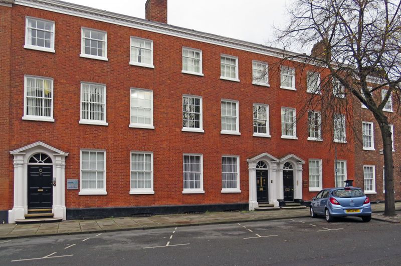
Row of 3 town houses, now consulting rooms. Late C18; altered. Red brick in Flemish bond (roof not visible). Double-depth plan, each house single-fronted, with back extensions. Three storeys over cellars, a 9-bay facade (each house with 3 windows), with plinth and modillioned cornice. Round-headed doorways with open-pedimented Tuscan doorcases, panelled doors and semi-circular fanlights with radiating glazing bars (No.16 to the left and Nos. 12 and 14 coupled); sashed windows with exposed boxes, raised sills and flat-arched heads, 12-paned at ground and 1st floors and 9-paned at 2nd floor. Ridge chimneys. Rear: large tripartite sashed windows; back extensions (Nos.14 and 16 coupled). Interior not inspected. Forms part of terrace on north side of street.
Listing NGR: SJ8343797929
External links are from the relevant listing authority and, where applicable, Wikidata. Wikidata IDs may be related buildings as well as this specific building. If you want to add or update a link, you will need to do so by editing the Wikidata entry.


Other nearby listed buildings