Latitude: 52.2282 / 52°13'41"N
Longitude: -2.7439 / 2°44'38"W
OS Eastings: 349283
OS Northings: 259144
OS Grid: SO492591
Mapcode National: GBR FJ.1RZM
Mapcode Global: VH84W.D877
Plus Code: 9C4V67H4+7C
Entry Name: Townsend House and Attached Walls
Listing Date: 24 July 1954
Last Amended: 15 March 1996
Grade: II
Source: Historic England
Source ID: 1255447
English Heritage Legacy ID: 459711
ID on this website: 101255447
Location: Leominster, County of Herefordshire, HR6
County: County of Herefordshire
Civil Parish: Leominster
Built-Up Area: Leominster
Traditional County: Herefordshire
Lieutenancy Area (Ceremonial County): Herefordshire
Church of England Parish: Leominster
Church of England Diocese: Hereford
Tagged with: Architectural structure
LEOMINSTER
SO4959 GREEN LANE 808-1/1/145 No.15 24/07/54 Townsend House and attached walls (Formerly Listed as: GREEN LANE No.15 Townsend House)
GV II
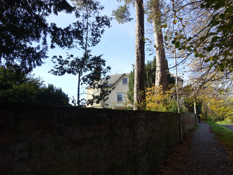
House. C17 and C18. English bond brick; stucco; plaster; hipped Welsh slate roof; various brick stacks; large brick and stone buttress stack to rear of wing. L-shaped on plan. EXTERIOR: North front (to street): 2 storeys; single-window range: C19 tripartite window with 2/2: 6/6: 2/2 sashes; two C19 6/6 sashes to ground floor, under jetty. Right returned side: 6/6 and small 2/2 sliding sashes, in stucco to 1st floor. Recessed wing to right has 2 advanced bays; to left, 6/6 sash over C19 ashlar porch with semicircular arch under enriched frieze on pilasters with figures; blocked C18(?) with inserted cross-window with leaded lights; to right, 6/6 sash over C18(?) moulded wood mullion and transom window with leaded lights; central C19 eight/eight sash flanked by wood mullion window with leaded lights, over large mullion and transom window with leaded lights, under moulded wood cornice. Left returned side: 6-panel door under flat hood, flanked by 6/6 sashes; gable over; buttress stack. Right returned side: C18 brickwork with storey band. Rear: three 6/6 sashes and blocked opening, to 1st floor. INTERIOR not inspected. SUBSIDIARY FEATURES: attached garden walls, of C18 and C19 brick on rubble base, extend for approx 150m to east and for approx 50m to west of street front. (RCHME: Herefordshire: 116 (6)).
Listing NGR: SO4928359144
External links are from the relevant listing authority and, where applicable, Wikidata. Wikidata IDs may be related buildings as well as this specific building. If you want to add or update a link, you will need to do so by editing the Wikidata entry.


Other nearby listed buildings