Approximate Location Map
Large Map »
Latitude: 53.7951 / 53°47'42"N
Longitude: -1.5423 / 1°32'32"W
OS Eastings: 430248
OS Northings: 433294
OS Grid: SE302332
Mapcode National: GBR BKM.8C
Mapcode Global: WHC9D.8VTZ
Plus Code: 9C5WQFW5+23
Entry Name: Numbers 165A and 166-169 Briggate
Listing Date: 17 July 1995
Grade: II
Source: Historic England
Source ID: 1255838
English Heritage Legacy ID: 465599
ID on this website: 101255838
Location: Steander, Leeds, West Yorkshire, LS1
County: Leeds
Electoral Ward/Division: City and Hunslet
Parish: Non Civil Parish
Built-Up Area: Leeds
Traditional County: Yorkshire
Lieutenancy Area (Ceremonial County): West Yorkshire
Church of England Parish: Leeds City
Church of England Diocese: Leeds
Tagged with: Building
SE3033SW
714-1/78/67
17/07/95
LEEDS
BRIGGATE
(East side)
Nos.165A AND 166-169 (Consecutive)
GV
II
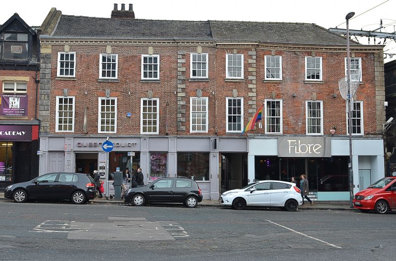
House and workshops. Early C18, altered C19 and C20. Red
brick, part overpainted, sandstone dressings; slate roof,
hipped to right, 3-flue stack to rear left.
3 storeys, 8 first-floor windows, the 2 centre windows in
slightly projecting quoined bay, quoins also to far left and
right; restored small-pane sashes to left, 4-pane sashes and
C20 frames to right; moulded sills, rubbed brick flat arches
with keystones. Fine modillion eaves cornice to right and
centre, eaves to left rebuilt above window head level mid C20.
C20 shop facades, entry to rear Queen's Court to right of
centre; rear ranges extend as north and south ranges of
Queen's Court (qv).
INTERIOR: not inspected but reputed to contain (c1987): cellar
below room far left reached by stone stair and having an ogee
stop to chamfered ceiling beam; in the first-floor centre
room, lit by 2 windows, mid C18 fittings including raised and
fielded-panels to window surrounds, shutters, below dado rail
and in eared architrave between windows; dentilled cornice.
Also an open-well cantilevered staircase, probably in original
position, between front range and north range of Queen's
Court, having turned balusters and moulded handrail. The stair
hall opened into a long ground-floor room in the north range
of Queen's Court (qv). Roof structure of king posts with
straight braces to ridge and struts between cross beam and
principal rafters.
HISTORICAL NOTE: the northern part, from the passageway,
probably built for a cloth merchant on the main market street
of Leeds; the cloth markets being removed from the open street
and into the cloth halls during the C18. The merchant will
have lived in part of the house, the ground floor left,
staircase, panelled room above being the most likely part. The
rooms on upper floors and to right of the entrance passage
probably used as workrooms, warehousing and showrooms/shops,
together with the north ranges of Queen's Court. Purchases of
cloth were made in the market or cloth halls and the merchant
employed workmen to complete the finishing processes before
sale to those making up the fabric.
The development of factory production resulted in the change
of use of such buildings in the early C19: the historical
record suggests that part of the building became a patent hat
warehouse, the premises of a hatter, woolstapler and insurance
agent by 1817. The principal use of the building in the
mid-later C19 was as the premises of Sidney and Stables, tea
coffee and spice dealer, latterly tea dealer and grocery
warehouse. Parts of the building were used by a stationer,
ironmonger, linen merchant, silk mercer and hosier during that
period.
The 1847 map indicates a ground floor facade with bow windows
flanking an entrance below window 3, a second door from the
street to far left; by 1885 shop windows had been inserted far
left. Similar in character to Nos 3-5 Briggate (qv).
(Beresford M: East End, West End; Leeds 1684-1842: 1988-;
Thornborrow, P & Moorhouse S, West Yorks Archaeological
Service: Queen's Court Lower Briggate, Leeds Restoration
Design Proposals: 1987-; Map of Leeds surveyed 1847: Ordnance
Survey Map of Leeds, surveyed 1847: 1850-; Lingard S,
University of Leeds: Index of properties in Briggate
(unpublished thesis)).
Listing NGR: SE3024833294
External links are from the relevant listing authority and, where applicable, Wikidata. Wikidata IDs may be related buildings as well as this specific building. If you want to add or update a link, you will need to do so by editing the Wikidata entry.


Other nearby listed buildings
