Approximate Location Map
Large Map »
Latitude: 53.7955 / 53°47'43"N
Longitude: -1.5443 / 1°32'39"W
OS Eastings: 430112
OS Northings: 433337
OS Grid: SE301333
Mapcode National: GBR BJM.T6
Mapcode Global: WHC9D.7VVP
Plus Code: 9C5WQFW4+57
Entry Name: 2, the Bourse
Listing Date: 22 March 1974
Last Amended: 11 September 1996
Grade: II
Source: Historic England
Source ID: 1255917
English Heritage Legacy ID: 465446
ID on this website: 101255917
Location: Granary Wharf, Leeds, West Yorkshire, LS1
County: Leeds
Electoral Ward/Division: City and Hunslet
Parish: Non Civil Parish
Built-Up Area: Leeds
Traditional County: Yorkshire
Lieutenancy Area (Ceremonial County): West Yorkshire
Church of England Parish: Leeds City
Church of England Diocese: Leeds
Tagged with: Building
LEEDS
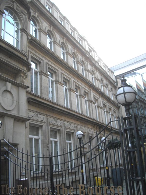
SE3033SW THE BOURSE
714-1/78/15 (East side)
22/03/74 No.2
(Formerly Listed as:
ALFRED STREET
No.3)
(Formerly Listed as:
BOAR LANE
(South side)
Nos.20A AND 21)
GV II
Offices and warehouse premises. c1880. Ashlar, grey slate
roof. Italianate style. 3 storeys, 9 bays, entrance bays 4 & 6
in an almost symmetrical facade. Doorway, bay 4, with moulded
architrave and rectangular fanlight; blocked wide round-arched
entrance, bay 6, with fluted pilasters and keyblocks. Windows:
ground floor in moulded architraves with scroll decoration
over, 1st floor rectangular with moulded heads, 2nd floor
round-headed with keyblocks. Moulded cornices to each floor
level, flat pilasters, moulded impost bands. Eaves obscured by
scaffolding at time of resurvey.
INTERIOR: not inspected but reputed to contain restaurant
premises to first floor, left, with ornate plaster ceiling,
linked to No.21 Boar Lane (qv).
HISTORICAL NOTE: the property was probably owned by the Leeds
Gas Light Company when Boar Lane was redeveloped in 1869; the
restaurant was in use by 1886 and at that date the rooms to
right of the wide entrance were used by WH Turner and Co.,
Tobacco Factory, (Insurance map).
One of the few late C19 unaltered ground-floor frontages in
the area.
(Insurance company plan of Leeds city centre: Leeds: 1886-;
Borough of Leeds: Improvement Plan of Building Sites in Leeds
City Centre: Leeds: 1869-).
Listing NGR: SE3011733336
External links are from the relevant listing authority and, where applicable, Wikidata. Wikidata IDs may be related buildings as well as this specific building. If you want to add or update a link, you will need to do so by editing the Wikidata entry.


Other nearby listed buildings
