Latitude: 53.8035 / 53°48'12"N
Longitude: -1.5447 / 1°32'40"W
OS Eastings: 430084
OS Northings: 434232
OS Grid: SE300342
Mapcode National: GBR BJJ.RB
Mapcode Global: WHC9D.7NPH
Plus Code: 9C5WRF34+C4
Entry Name: Gas Lamp Post on Pavement Between Numbers 16 and 17
Listing Date: 11 September 1996
Grade: II
Source: Historic England
Source ID: 1256187
English Heritage Legacy ID: 465172
ID on this website: 101256187
Location: Leeds, West Yorkshire, LS2
County: Leeds
Electoral Ward/Division: City and Hunslet
Parish: Non Civil Parish
Built-Up Area: Leeds
Traditional County: Yorkshire
Lieutenancy Area (Ceremonial County): West Yorkshire
Church of England Parish: St Martin, Potternewton with All Souls, Little London
Church of England Diocese: Leeds
Tagged with: Gas streetlight
LEEDS
SE3034 QUEEN SQUARE
714-1/29/347 (North East side)
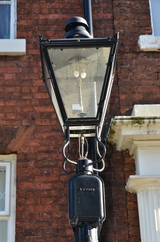
Gas lamp post on pavement between
Nos.16 and 17
GV II
Gas lamp post. Late C19. Cast-iron. Tapering fluted shaft on a
roll-moulded base, restored lantern with ventilator.
Listing NGR: SE3008434232
External links are from the relevant listing authority and, where applicable, Wikidata. Wikidata IDs may be related buildings as well as this specific building. If you want to add or update a link, you will need to do so by editing the Wikidata entry.


Other nearby listed buildings