Approximate Location Map
Large Map »
Latitude: 53.9562 / 53°57'22"N
Longitude: -1.0733 / 1°4'24"W
OS Eastings: 460903
OS Northings: 451521
OS Grid: SE609515
Mapcode National: GBR NQYP.FK
Mapcode Global: WHFC3.HT3G
Plus Code: 9C5WXW4G+FM
Entry Name: Gate Approximately 100 Metres South West of St Margarets Church
Listing Date: 24 June 1983
Last Amended: 14 March 1997
Grade: II
Source: Historic England
Source ID: 1256259
English Heritage Legacy ID: 465109
ID on this website: 101256259
Location: Foss Islands, York, North Yorkshire, YO1
County: York
Electoral Ward/Division: Guildhall
Parish: Non Civil Parish
Built-Up Area: York
Traditional County: Yorkshire
Lieutenancy Area (Ceremonial County): North Yorkshire
Church of England Parish: York St Denys
Church of England Diocese: York
Tagged with: Gate
YORK
SE6051NE WALMGATE
1112-1/17/1176 (North East side)
24/06/83 Gate approx 100 metres south-west of
St Margaret's Church
(Formerly Listed as:
WALMGATE
Gates & standards to Churchyard of
St Margaret's w. St Peter-le-Willows
Church)
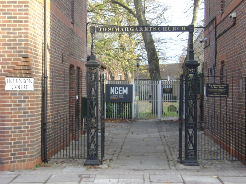
GV II
Pair of gates, gate piers and overthrow to churchyard of St
Margaret's church (qv). 1851-52, restored 1993. By John Walker
of the Walker Ironfoundry. Cast-iron. Gates of turned railings
with conical finials incorporate bands of Greek key motif.
Openwork gate piers, approximately 2.50 metres high,
rectangular on plan, of diagonal crossed bars and bands of
Greek key, have flat cornice caps. Squat twisted balusters
support flat overthrow, cast with the words: "TO ST MARGARET'S
CHURCH".
(York Historian: Malden J: The Walker Ironfoundry, York,
c.1825-1923: York: 1976-: 43).
Listing NGR: SE6090251522
External links are from the relevant listing authority and, where applicable, Wikidata. Wikidata IDs may be related buildings as well as this specific building. If you want to add or update a link, you will need to do so by editing the Wikidata entry.


Other nearby listed buildings
