Approximate Location Map
Large Map »
Latitude: 53.9607 / 53°57'38"N
Longitude: -1.084 / 1°5'2"W
OS Eastings: 460198
OS Northings: 452007
OS Grid: SE601520
Mapcode National: GBR NQWM.3Y
Mapcode Global: WHFC3.BQ11
Plus Code: 9C5WXW68+7C
Entry Name: 10 and 10A, Stonegate
Listing Date: 1 July 1968
Grade: II
Source: Historic England
Source ID: 1256539
English Heritage Legacy ID: 464798
Also known as: 10, Stonegate
10A, Stonegate
ID on this website: 101256539
Location: York, North Yorkshire, YO1
County: York
Electoral Ward/Division: Guildhall
Parish: Non Civil Parish
Built-Up Area: York
Traditional County: Yorkshire
Lieutenancy Area (Ceremonial County): North Yorkshire
Church of England Parish: York St Helen Stonegate with St Martin Coney Street
Church of England Diocese: York
Tagged with: Building
YORK
SE6052SW STONEGATE
1112-1/27/1013 (North West side)
01/07/68 Nos.10 AND 10A
GV II
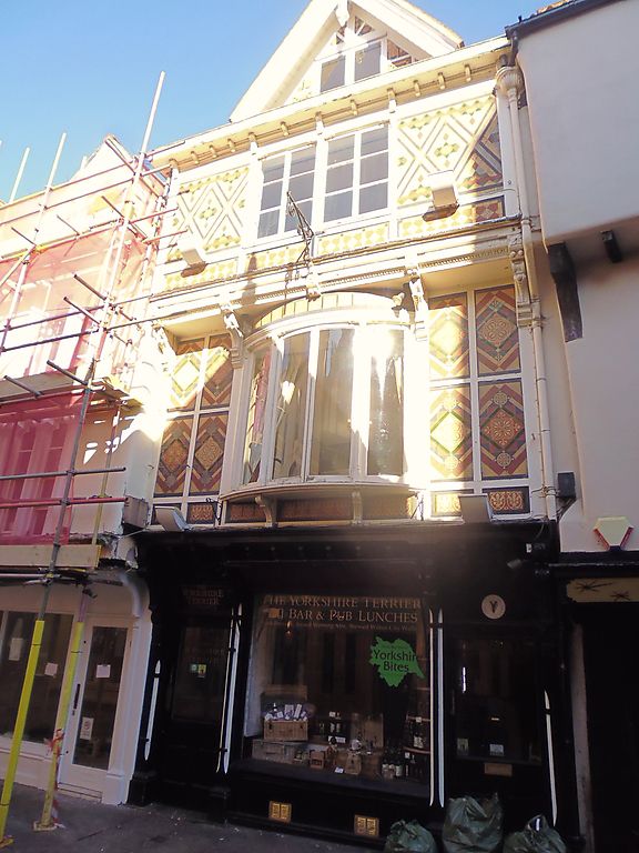
House; now shop and offices. Probably early C17, remodelled
with new front in late C19. Front covered in ceramic tiles;
timber shopfront; pantile roof, hipped at front with high
gabled and bargeboarded dormer with finial.
EXTERIOR: 3 storeys and attic; 1-bay gabled front with jettied
first and second floors. Plate glass shop window with glazed
and panelled shop door to right, panelled upstairs door to
left: carved frieze houses roller blind and cased bressumer on
carved brackets forms shopfront cornice. On first floor,
4-light bow window with casements in chamfered and bar-stopped
frames projects on grooved console brackets. On second floor,
window is of two pairs of 3-pane casements, above bressumer
carved with a variety of motifs, carried on ornate console
brackets. Modillioned and bracketed eaves cornice with fluted
bowl rainwater head at right end.
INTERIOR: not inspected. RCHM suggests may contain early
timber-frame.
(City of York: RCHME: The Central Area: HMSO: 1981-: 221).
Listing NGR: SE6019852007
External links are from the relevant listing authority and, where applicable, Wikidata. Wikidata IDs may be related buildings as well as this specific building. If you want to add or update a link, you will need to do so by editing the Wikidata entry.


Other nearby listed buildings
