Latitude: 53.9636 / 53°57'48"N
Longitude: -1.0764 / 1°4'35"W
OS Eastings: 460691
OS Northings: 452340
OS Grid: SE606523
Mapcode National: GBR NQXL.RX
Mapcode Global: WHFC3.FMNT
Plus Code: 9C5WXW7F+CC
Entry Name: 36, Monkgate
Listing Date: 14 June 1954
Grade: II
Source: Historic England
Source ID: 1257204
English Heritage Legacy ID: 464118
ID on this website: 101257204
Location: The Groves, York, North Yorkshire, YO31
County: York
Electoral Ward/Division: Guildhall
Parish: Non Civil Parish
Built-Up Area: York
Traditional County: Yorkshire
Lieutenancy Area (Ceremonial County): North Yorkshire
Church of England Parish: York St Michael-le-Belfrey
Church of England Diocese: York
Tagged with: Building
YORK
SE6052SE MONKGATE
1112-1/14/733 (South East side)
14/06/54 No.36
GV II
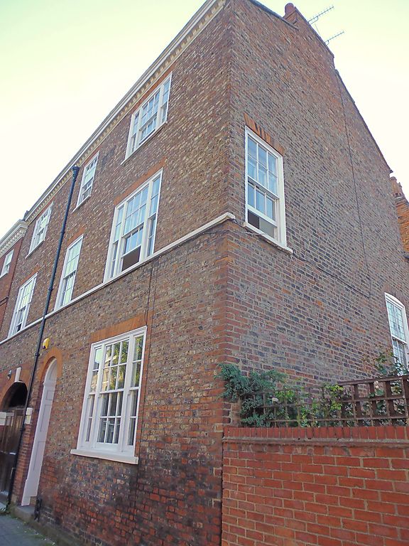
House. 1796-8 with earlier remains. Brick in Flemish bond.
Pantiled roof.
EXTERIOR: 3 storeys and 3 bays, with a 1st floor sill band and
modillion cornice gutter. The left-hand bay has an earlier
carriage entrance remaining on the ground floor, with an
elliptical brick archway. To its left is a blind window with a
projecting sill and a rubbed brick flat arch. The right-hand
window on the ground floor is a tripartite sash with glazing
bars with a rubbed brick flat arch. The windows to the outer
bays of the upper floors are similar. The windows of the
central bay, which contains the doorway, are glazing bar
sashes with rubbed brick flat arches. The doorway has a
semicircular brick arch, a recessed door with 6 raised and
fielded panels, a fanlight, panelled reveals, and recessed
stone steps. To the left of the middle windows there is a lead
hopper and downpipe. Chimneys to left and right.
INTERIOR: RCHM records original staircase and a single
original fireplace on the first floor.
(An Inventory of the Historical Monuments of the City of York:
RCHME: Outside the City Walls East of the Ouse: HMSO: 1975-:
89).
Listing NGR: SE6069152340
External links are from the relevant listing authority and, where applicable, Wikidata. Wikidata IDs may be related buildings as well as this specific building. If you want to add or update a link, you will need to do so by editing the Wikidata entry.


Other nearby listed buildings