Latitude: 53.9575 / 53°57'26"N
Longitude: -1.0873 / 1°5'14"W
OS Eastings: 459985
OS Northings: 451650
OS Grid: SE599516
Mapcode National: GBR NQVP.D3
Mapcode Global: WHFC3.8SHH
Plus Code: 9C5WXW47+X3
Entry Name: 40, Micklegate
Listing Date: 18 February 1991
Grade: II
Source: Historic England
Source ID: 1257328
English Heritage Legacy ID: 463990
ID on this website: 101257328
Location: York, North Yorkshire, YO1
County: York
Electoral Ward/Division: Micklegate
Parish: Non Civil Parish
Built-Up Area: York
Traditional County: Yorkshire
Lieutenancy Area (Ceremonial County): North Yorkshire
Church of England Parish: Micklegate Holy Trinity
Church of England Diocese: York
Tagged with: Building
YORK
SE5951NE MICKLEGATE
1112-1/15/645 (North side)
18/02/91 No.40
GV II
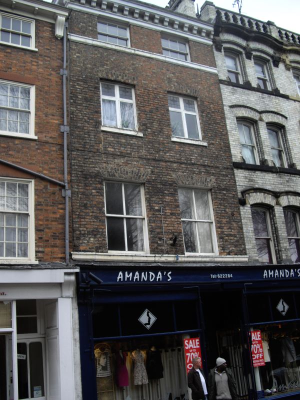
Shop and flats. c1840, with later C19 and C20 alteration and
extension. Pink mottled brick in Flemish bond at front; pink
and red mottled brick in English garden-wall bond at rear;
painted stone and timber dressings. Moulded eaves cornice on
heavy grooved brackets to slate roof; left end brick stack.
EXTERIOR: 3 storeys and attic; 2-window front. Pilastered
shopfront with dentil cornice on paired scrolled brackets,
complete with blind boxes and fittings. First floor windows
are 4-pane sashes; those on second floor altered to C20
2-light casements with coloured glass upper lights; attic
windows squat 6-pane sashes. First and second floor windows
have flat arches. Moulded cornice above shopfront forms sill
band to first floor windows; second floor windows have painted
stone sills; moulded band beneath attic windows.
INTERIOR: open-string cantilevered staircase around oval well,
with timber stairs, slender cast-iron stick balusters and
moulded swept-up mahogany handrail; moulded dado rail. In rear
room, late C19 fireplace and grate, with moulded cornice shelf
on shaped brackets.
(City of York: RCHME: South-west of the Ouse: HMSO: 1972-:
127).
Listing NGR: SE5998251655
External links are from the relevant listing authority and, where applicable, Wikidata. Wikidata IDs may be related buildings as well as this specific building. If you want to add or update a link, you will need to do so by editing the Wikidata entry.


Other nearby listed buildings