Approximate Location Map
Large Map »
Latitude: 52.854 / 52°51'14"N
Longitude: -1.9856 / 1°59'7"W
OS Eastings: 401069
OS Northings: 328501
OS Grid: SK010285
Mapcode National: GBR 27V.2TL
Mapcode Global: WHBDP.GJQD
Plus Code: 9C4WV237+JQ
Entry Name: Chartley Castle
Listing Date: 15 January 1968
Grade: II*
Source: Historic England
Source ID: 1258139
English Heritage Legacy ID: 444419
ID on this website: 101258139
Location: Stafford, Staffordshire, ST18
County: Staffordshire
District: Stafford
Civil Parish: Stowe-by-Chartley
Traditional County: Staffordshire
Lieutenancy Area (Ceremonial County): Staffordshire
Tagged with: Castle
STOWE-BY-CHARTLEY
1.
2385
SK 02 NW 1/5 15.1.68. Chartley Castle
II*
2.
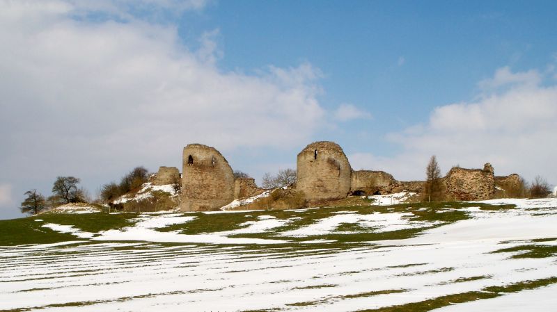
Ruined. Remains of early Cl3 building within extensive earth-works The
enclosure is quadrangular with the remains of the keep at 1 end on a motte.
At the lower end are 2 massive circular towers with walls about 12
feet thick and filth slit openings. The site is so overgrown that a care-
ful examination is impossible. Mary Queen of Scots-imprisoned here Jan-
Sept, 1586. A.M.
Listing NGR: SK0106928501
External links are from the relevant listing authority and, where applicable, Wikidata. Wikidata IDs may be related buildings as well as this specific building. If you want to add or update a link, you will need to do so by editing the Wikidata entry.


Other nearby listed buildings
