Approximate Location Map
Large Map »
Latitude: 51.0689 / 51°4'7"N
Longitude: -1.7939 / 1°47'38"W
OS Eastings: 414535
OS Northings: 129970
OS Grid: SU145299
Mapcode National: GBR 517.WT9
Mapcode Global: FRA 7649.6Y4
Plus Code: 9C3W3694+HC
Entry Name: 6 and 7, Queen Street
Listing Date: 12 October 1972
Grade: II
Source: Historic England
Source ID: 1258510
English Heritage Legacy ID: 445096
ID on this website: 101258510
Location: Salisbury, Wiltshire, SP1
County: Wiltshire
Civil Parish: Salisbury
Built-Up Area: Salisbury
Traditional County: Wiltshire
Lieutenancy Area (Ceremonial County): Wiltshire
Church of England Parish: Salisbury St Thomas and St Edmund
Church of England Diocese: Salisbury
Tagged with: Building
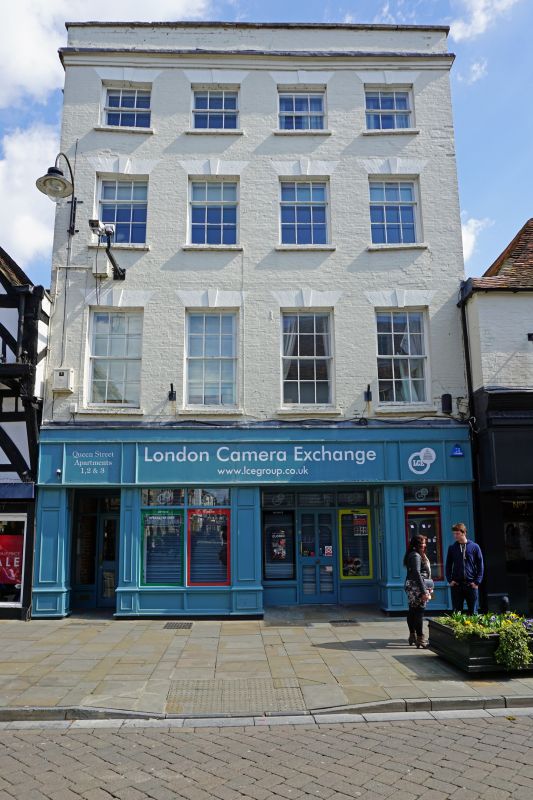
QUEEN STREET
1.
1594 (East Side)
Nos 6 & 7
SU 1429 NE 4/330
II GV
2.
Late C18 front, possibly to earlier building. Tall 4 storeys painted brick
with moulded cornice and parapet with stone coping. 4 windows to upper floors,
recessed sashes, glazing bars intact, keystones over. Modern shop fronts on
ground floor.
Nos 5 to 21 (consec) form a group.
Listing NGR: SU1453629967
External links are from the relevant listing authority and, where applicable, Wikidata. Wikidata IDs may be related buildings as well as this specific building. If you want to add or update a link, you will need to do so by editing the Wikidata entry.


Other nearby listed buildings
