Approximate Location Map
Large Map »
Latitude: 51.443 / 51°26'34"N
Longitude: 0.7479 / 0°44'52"E
OS Eastings: 591062
OS Northings: 175137
OS Grid: TQ910751
Mapcode National: GBR RS1.HWX
Mapcode Global: VHKJ0.XZ7P
Plus Code: 9F32CPVX+55
Entry Name: Archway House Building Number 23
Listing Date: 1 August 1968
Last Amended: 13 August 1999
Grade: II*
Source: Historic England
Source ID: 1258986
English Heritage Legacy ID: 445989
ID on this website: 101258986
Location: Blue Town, Swale, Kent, ME12
County: Kent
District: Swale
Electoral Ward/Division: Sheerness
Parish: Sheerness
Built-Up Area: Sheerness
Traditional County: Kent
Lieutenancy Area (Ceremonial County): Kent
Tagged with: Building
TQ 9175 SW MAIN ROAD
(South side), Sheerness Dockyard
933/2/107
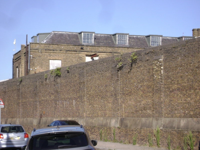
Archway House,
01.08.1968 Building number 23
GV II*
Sawyers' and carpenters' shop and stores, now offices. 1824-30, probably by Edward Holl, architect to the Navy Board, and carried out by William Miller, architect, and Sir John Rennie Jnr and George Rennie, engineers. Yellow stock brick with granite dressings, cast-iron internal frame and slate hipped mansard roof. PLAN: 5 single-depth sections, 3 for ground-floor saw pits alternating with timber seasoning stores, separated by stair wells. EXTERIOR: 2 storeys and attic; five 5-window sections separated by 1- window stair bays. Each section separated by a recessed stair bay and raised fire-break walls, with rusticated granite to the piers of a full-length round-arched arcade with rubbed brick heads, plant band, thin cornice and parapet. Late C19 or mid C20 glazing to the formerly open arcade, with round-arched doorways set in matching recesses to the stair bays, and rubbed brick heads to first-floor 8/8-pane sashes; flat-headed dormers with 6/6-pane sashes, some iron, to each bay. 3-window returns with small round-arched ground-floor windows in larger arched recesses, and a large central round-arched hoist bay to the first floor. Blocks 2, 3 and 4 had larger loading doors to the central first-floor bay. INTERIOR: contains an internal cast-iron frame of posts to the heads of which slot T-section beams with arched webs and sockets in the sides for fish belly joists bearing flagstone floors; the timber seasoning bays Nos 2 and 4 have sockets at 3 levels cast into the columns for carrying seasoning racks. First floor similar, though that at the N end, the mould loft, is without columns. Attic with cast-iron roof, blocks 2 and 5 with canted tie beams with pierced webs and axial arched beams between iron posts, the other bays with queen rods to I-section ties and rafters. Original cantilevered stone open-well stairs with iron stick balusters on the W side; cast-iron harr-hung 6-panel doors, one survives in the S end. HISTORY: the fire-proof frame is related to similar structures in Holl's lead works at Chatham and ropery at Devonport (qqv), and also to Rennie's work at the Royal William Yard, Devonport, and part of a rigorous attempt to reduce the fire hazard. Contained 15 saw pits in blocks 1,3 and 5, seasoning stores, with mould loft, stores and carpenters's shop on the upper floor, and attic stores. The hand saw pits were among the last built for the Navy before the changeover to metal ships, and were replaced by the steam saw mill (qv) from 1856, with which this forms an interesting comparison as an iron-framed building for sawing. Of considerable interest as a fire-proof integrated timber workshop within the elder Rennie's plan for the completely rebuilt yard. Forms a central part of a unique planned early C19 dockyard. (Sources: Coad J: The Royal Dockyards 1690-1850: Aldershot: 1989: 149-150; Rennie Sir J: The Formation and Construction of British and Foreign Harbours: London: 1851: 41; Sheerness, the Dockyard, Defences and Blue Town: 1995: NBR BI NO 93279).
Listing NGR: TQ9106275137
External links are from the relevant listing authority and, where applicable, Wikidata. Wikidata IDs may be related buildings as well as this specific building. If you want to add or update a link, you will need to do so by editing the Wikidata entry.


Other nearby listed buildings
