Approximate Location Map
Large Map »
Latitude: 51.2806 / 51°16'50"N
Longitude: 1.0776 / 1°4'39"E
OS Eastings: 614725
OS Northings: 157999
OS Grid: TR147579
Mapcode National: GBR TY2.P81
Mapcode Global: VHLGM.M2JL
Plus Code: 9F3373JH+72
Entry Name: 13 and 13A, St Peter's Street
Listing Date: 3 December 1949
Grade: II
Source: Historic England
Source ID: 1260046
English Heritage Legacy ID: 441708
ID on this website: 101260046
Location: Canterbury, Kent, CT1
County: Kent
District: Canterbury
Electoral Ward/Division: Westgate
Parish: Non Civil Parish
Built-Up Area: Canterbury
Traditional County: Kent
Lieutenancy Area (Ceremonial County): Kent
Tagged with: Building
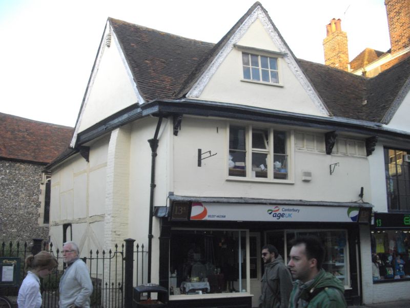
1.
944 ST PETER'S STREET
(North East Side)
Nos 13 and 13A
TR 1457 NE 4/71 3.12.49.
TR 1458 SE 2/71
II GV
2.
C16. 2 storeys and gables. Timber framed now stuccoed. Old tiled roof with
fine calved bargeboards. Sashes in gables. lst floor has 1 casement and
2 restored sashes. Later shop fronts. Gable overhang is supported on 2 console
brackets and 2 fine carved figures. Side elevation has exposed timber frame
with curved braces and 1 4 centred arched window opening (now blocked). Rear
elevation is early C18 brick.
Nos 12, 13, 13A and the Church of St Peter form a group.
Listing NGR: TR1472558002
External links are from the relevant listing authority and, where applicable, Wikidata. Wikidata IDs may be related buildings as well as this specific building. If you want to add or update a link, you will need to do so by editing the Wikidata entry.


Other nearby listed buildings
