Latitude: 51.5164 / 51°30'59"N
Longitude: -0.0687 / 0°4'7"W
OS Eastings: 534103
OS Northings: 181490
OS Grid: TQ341814
Mapcode National: GBR XB.QL
Mapcode Global: VHGR0.R4KV
Plus Code: 9C3XGW8J+HG
Entry Name: Wall of Former St Mary's Churchyard
Listing Date: 27 September 1973
Grade: II
Source: Historic England
Source ID: 1260066
English Heritage Legacy ID: 206363
ID on this website: 101260066
Location: Whitechapel, Tower Hamlets, London, E1
County: London
District: Tower Hamlets
Electoral Ward/Division: Spitalfields & Banglatown
Parish: Non Civil Parish
Built-Up Area: Tower Hamlets
Traditional County: Middlesex
Lieutenancy Area (Ceremonial County): Greater London
Church of England Parish: St Dunstan Stepney
Church of England Diocese: London
Tagged with: Wall
WHITECHAPEL ROAD E1
1.
4431
(South Side)
Wall of former St Mary's
Churchyard
TQ 3481 15/518
II
2.
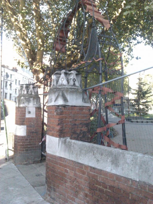
C19. Red brick wall with deep white stone capping. Red brick gate piers with
white stone bands and carved stone caps.
Listing NGR: TQ3410381490
External links are from the relevant listing authority and, where applicable, Wikidata. Wikidata IDs may be related buildings as well as this specific building. If you want to add or update a link, you will need to do so by editing the Wikidata entry.


Other nearby listed buildings