Approximate Location Map
Large Map »
Latitude: 53.3761 / 53°22'34"N
Longitude: -2.0257 / 2°1'32"W
OS Eastings: 398386
OS Northings: 386587
OS Grid: SJ983865
Mapcode National: GBR GY9D.7G
Mapcode Global: WHBB4.VDKM
Plus Code: 9C5V9XGF+FP
Entry Name: High Cliff Farmhouse
Listing Date: 11 October 1985
Grade: II
Source: Historic England
Source ID: 1260306
English Heritage Legacy ID: 441098
ID on this website: 101260306
Location: Brook Bottom, Stockport, Greater Manchester, SK22
County: Stockport
Electoral Ward/Division: Marple South
Parish: Non Civil Parish
Traditional County: Derbyshire
Lieutenancy Area (Ceremonial County): Greater Manchester
Church of England Parish: Mellor
Church of England Diocese: Chester
Tagged with: Farmhouse
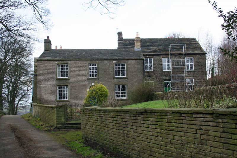
SJ 98 NE MARPLE BROOK BOTTOM
7/59 High Cliff
- Farmhouse
G.V. II
Farmhouse. Early C19. Hammer dressed stone with C20 tile
roof. Double-depth central-entrance plan with 2 storeys and
a double-span roof. 3 bays, the central C20 door having a
square-cut surround, radial fanlight, impost blocks and
keystone. 2 16-pane sash windows on each floor as well as a
12-pane sash above the door, all with square-cut surrounds.
Plain stone eaves cornice and gable stacks. The rear shows
signs of several later periods of alteration/addition.
Listing NGR: SJ9838686587
External links are from the relevant listing authority and, where applicable, Wikidata. Wikidata IDs may be related buildings as well as this specific building. If you want to add or update a link, you will need to do so by editing the Wikidata entry.


Other nearby listed buildings
