Latitude: 53.4015 / 53°24'5"N
Longitude: -1.5505 / 1°33'1"W
OS Eastings: 429986
OS Northings: 389505
OS Grid: SK299895
Mapcode National: GBR KYM3.4C
Mapcode Global: WHCCB.4RYP
Plus Code: 9C5WCC2X+JR
Entry Name: Packhorse bridge over River Loxley at Croft House
Listing Date: 22 May 1990
Grade: II
Source: Historic England
Source ID: 1261011
English Heritage Legacy ID: 382371
ID on this website: 101261011
Location: Loxley, Sheffield, South Yorkshire, S6
County: Sheffield
Civil Parish: Bradfield
Traditional County: Yorkshire
Lieutenancy Area (Ceremonial County): South Yorkshire
Church of England Parish: Stannington Christ Church
Church of England Diocese: Sheffield
Tagged with: Packhorse bridge
This list entry was subject to a Minor Amendment on 18 November 2024 to amend the name and address and reformat the text to current standards
SK 28 NE
SK 2998 8951
13/127
BRADFIELD
ROWELL LANE (east side, off)
Packhorse bridge over River Loxley at Croft House
(Formerly listed as Packhorse Bridge over River Loxley at Croft House, ROWEL LANE (east side, off))
II
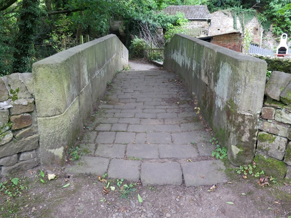
Packhorse bridge. Probably C18, restored 1864. Coursed squared stone, that to parapet C19 and vertically tooled. Single segmental arch bridging wide span having raised keystone with date "1864" and initials "FS". Ashlar band and parapet rising to peak in centre, the parapet with chamfered top. Causeway paved with setts. This building was damaged in the Sheffield flood, when the Dale Dike Reservoir burst, but was retained in the same location when restored.
Listing NGR: SK2998689505
External links are from the relevant listing authority and, where applicable, Wikidata. Wikidata IDs may be related buildings as well as this specific building. If you want to add or update a link, you will need to do so by editing the Wikidata entry.


Other nearby listed buildings