Latitude: 51.4118 / 51°24'42"N
Longitude: 0.1343 / 0°8'3"E
OS Eastings: 548528
OS Northings: 170244
OS Grid: TQ485702
Mapcode National: GBR R6.VYW
Mapcode Global: VHHNZ.8SW3
Plus Code: 9F32C46M+PP
Entry Name: Old Church of St Botolph
Listing Date: 4 July 1991
Grade: II
Source: Historic England
Source ID: 1261527
English Heritage Legacy ID: 358656
ID on this website: 101261527
Location: St Botolphs Church, Upper Ruxley, Bromley, London, DA14
County: London
District: Bromley
Electoral Ward/Division: Cray Valley East
Parish: Non Civil Parish
Traditional County: Kent
Lieutenancy Area (Ceremonial County): Greater London
Church of England Parish: North Cray St James
Church of England Diocese: Rochester
The following building shall be added:
MAIDSTONE ROAD (off)
TQ 47 SE
7/103 Old Church of St Botolph
GV II
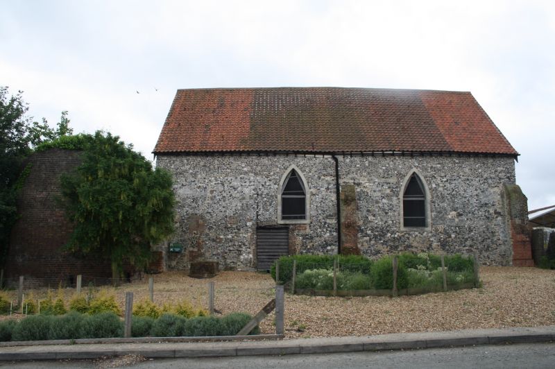
Former church, later barn, derelict at time of survey, C13
converted into a barn in late C18 and oast kiln added in early
C19. Built of flint and stone rubble with stone dressings, 3-
brick press to north side weather-boarded cart entrance to south
side and pantiled roof. West end has blocked arched west window
and blocked arched doorcase below it. The window has a later C18
smaller red brick surround and casement. 2 buttresses of flint,
brick and stone. South side has end buttresses, C18 off central
hipped cart entrance and arched window with inserted C20
casement. North side has 3 brick buttresses traces of 2 arched
windows filled in with church and C18 brick doorcase. East end
has outline of arched east window, blocked in with C18 brickwork.
Interior retains C13 arched piscina and double sedilia. Late C18
roof structure of angled green struts, through purlins and collar
beams. To the north east end is an early C19 cylindrical stock
brick oast house with roof missing at time of survey. It is
thought the building went out of use as a church in the C16.
Listing NGR: TQ4852870244
External links are from the relevant listing authority and, where applicable, Wikidata. Wikidata IDs may be related buildings as well as this specific building. If you want to add or update a link, you will need to do so by editing the Wikidata entry.


Other nearby listed buildings