Approximate Location Map
Large Map »
Latitude: 51.5722 / 51°34'19"N
Longitude: -1.1212 / 1°7'16"W
OS Eastings: 460999
OS Northings: 186287
OS Grid: SU609862
Mapcode National: GBR 91F.CBX
Mapcode Global: VHCYP.JR34
Plus Code: 9C3WHVCH+VG
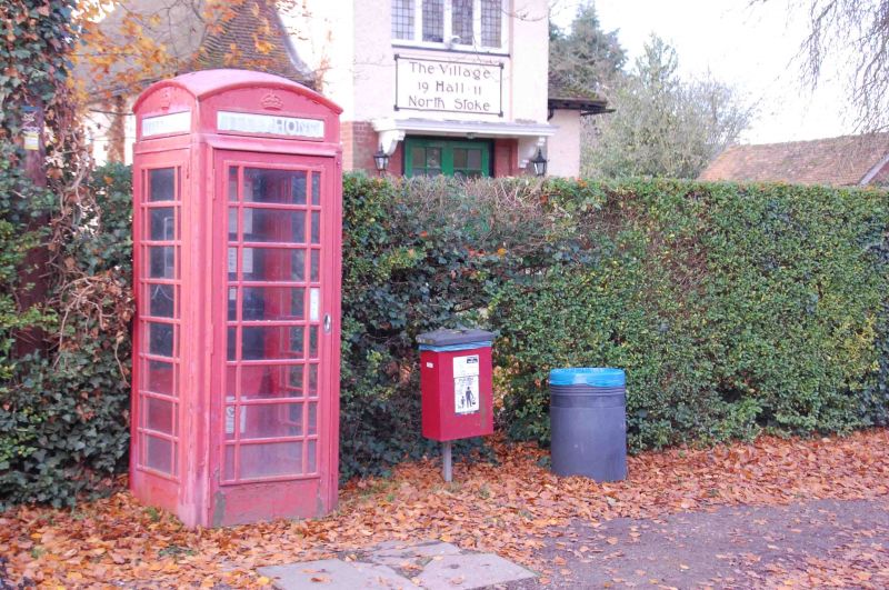
Entry Name: K6 Telephone Kiosk
Listing Date: 12 October 1989
Grade: II
Source: Historic England
Source ID: 1261769
English Heritage Legacy ID: 436702
ID on this website: 101261769
Location: North Stoke, South Oxfordshire, OX10
County: Oxfordshire
District: South Oxfordshire
Civil Parish: Crowmarsh
Built-Up Area: North Stoke
Traditional County: Oxfordshire
Lieutenancy Area (Ceremonial County): Oxfordshire
Church of England Parish: North Stoke
Church of England Diocese: Oxford
Tagged with: K6 telephone box
The following kiosk shall be added to the list:
SU 68 NW CROWMARSH NORTH STOKE
The Street
2/139 K6 Telephone Kiosk
GV II
Telephone kiosk. Type K6. Designed 1935 by Sir Giles Gilbert Scott. Made by
various contractors. Cast iron. Square kiosk with domed roof. Unperforated
crowns to top panels and margin glazing to windows and door.
Listing NGR: SU6099886287
External links are from the relevant listing authority and, where applicable, Wikidata. Wikidata IDs may be related buildings as well as this specific building. If you want to add or update a link, you will need to do so by editing the Wikidata entry.


Other nearby listed buildings
