Approximate Location Map
Large Map »
Latitude: 51.2716 / 51°16'17"N
Longitude: -0.8975 / 0°53'50"W
OS Eastings: 477008
OS Northings: 153069
OS Grid: SU770530
Mapcode National: GBR C82.7XM
Mapcode Global: VHDXT.D9DK
Plus Code: 9C3X74C3+J2
Entry Name: Baseley's Bridge
Listing Date: 26 June 1987
Grade: II
Source: Historic England
Source ID: 1261855
English Heritage Legacy ID: 136512
ID on this website: 101261855
Location: Hart, Hampshire, RG27
County: Hampshire
District: Hart
Civil Parish: Winchfield
Traditional County: Hampshire
Lieutenancy Area (Ceremonial County): Hampshire
Church of England Parish: Dogmersfield All Saints
Church of England Diocese: Winchester
Tagged with: Bridge
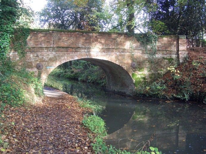
DOGMERSFIELD BASINGSTOKE CANAL
SU 75 SE
9/4 Baseley's Bridge
-
- II
1792. Cambered arch across canal and towpath; also curved on plan, with straight
cutwaters. Red brickwork, projecting band below parapet, which ends in square
pillars with white stone plain caps. Oval metal plaque above the arch states:-
Baseley's Bridge; built 1792: restored 1975: HCC.
Listing NGR: SU7726552028
External links are from the relevant listing authority and, where applicable, Wikidata. Wikidata IDs may be related buildings as well as this specific building. If you want to add or update a link, you will need to do so by editing the Wikidata entry.


Other nearby listed buildings
